|
|
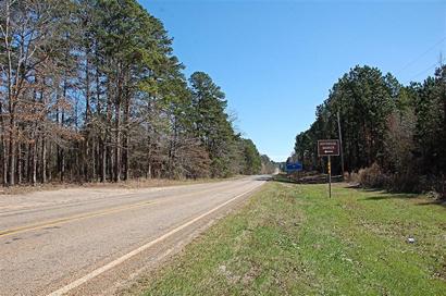
Travelers
who take the time to wander down Farm Road 31 between Deadwood,
Texas, and Logansport, Louisiana, will find a one-of-a-kind historical
landmark.
A granite shaft set into the ground on April 23, 1841, marks the only
international boundary existing within the continental United States. |
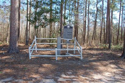
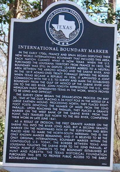
International
Boundary Republic of Texas-United States Marker
Photo courtesy Gerald
Massey, February 2009 |
 |
The marker established
the boundary between Texas and Louisiana,
but there was a time when the border underwent contests between France,
Spain, the U.S. and the Republic of Texas.
Before there was a Texas, both France and Spain claimed the region
on both sides of the Sabine
River -- an area known as the �neutral ground� or �no man�s land�
because of early explorations by both nations.
French explorers claimed all land drained by the Mississippi River
and its tributaries as Louisiana Territory. Spain claimed all southern
lands beginning with the first watershed west of the Mississippi.
The dispute arose over claims that the �first watershed� was the Sabine
or the Atchafalaya River. As a result the land between the two rivers
was claimed by both nations. When the U.S. purchased the Louisiana
territory in 1803 and inherited France�s claims, the U.S. and Spain
agreed that the disputed strip would be neutral territory until an
agreement could be reached by the two nations.
The strip soon became a refuge for outlaws and deserters seeking to
avoid the laws of any government, leading to the violent Regulator-Moderator
War in Shelby
and surrounding counties.
The boundary was further confused in 1819 when the U.S. purchased
Florida from Spain and a new, tentative agreement established the
Sabine as the international boundary. Texas, at the time, was still
Spanish territory, but became a part of Mexico when Mexico won its
independence from Spain.
When
the Republic
of Texas was born in 1836, it became a matter of urgency to mark
the actual boundary between the Republic and the U.S.
A joint commission was established in 1838 to survey and map the land
along the boundary. W.J. Stone, a young engineer, was commissioned
by President Martin Van Buren to perform the task �with all speed
and accuracy.� The work was scheduled for completion in 1840, but
wasn�t actually finished until 1841.
The western bank of the Sabine
was mapped and marked as the boundary from its mouth to the 32nd parallel,
just north of Logan�s Ferry (today�s Logansport). |
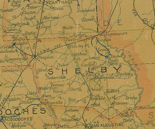 |
1907 Shelby
County postal map showing Deadwood,
Logansport and Sabine River
From Texas state map #2090
Courtesy Texas General Land Office |
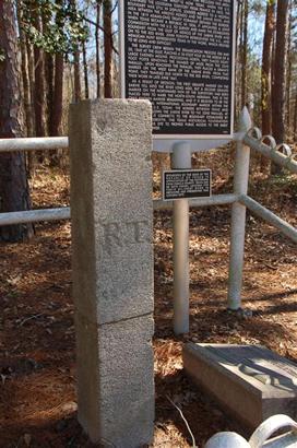
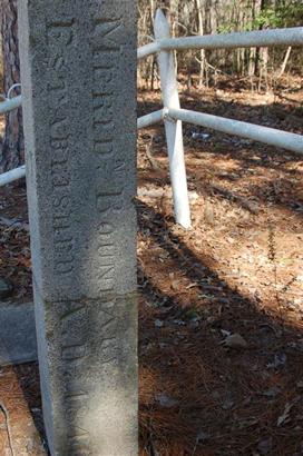
The granite block
marking the International Boundary
Photo
courtesy Gerald
Massey, February 2009 |
To establish
the line, a granite shaft was driven into the ground near the river.
Three miles north, a second shaft was set. Each mile between the two
shafts was marked by an earthen mound containing bottled information
and a wooden mileage pole.
With the passage of time and a crumbling river bank, the shaft on
the Sabine was lost.
The remaining marker on Farm Road 31 was damaged in the 1920s by loggers,
but was repaired and still stands about 50 yards off the highway between
Deadwood and Logansport.
The landmark carries three simple inscription. On the south side are
the words, �Merid. Boundary Established 1840.� On the east side, it
reads: �U.S.� and on the west side are the words, �R.T� for Republic
of Texas. |
International
Boundary Historical Marker
Photo courtesy Gerald
Massey, February 2009 |
An
illegal trophy collector tried to dig up the marker in the 1970s,
but gave up when he discovered it had a concrete foundation of ten
to fourteen feet.
Apparently, someone in the past wanted to make darned sure the marker
wasn�t going anywhere.
© Bob
Bowman
Bob Bowman's East Texas
February 1, 2005 Column, modifies April, 29, 2012
A weekly column syndicated in 109 East Texas newspapers
(Bob Bowman of Lufkin
is the author of more than 50 books about East Texas history and folklore) |
|
|