|
Canoeists Take
On Pristine Texas River
An 8-day 60-mile
canoe trip down the Pecos River
from Pandale to Amistad Reservoir
by
SANDRA R. BILLINGSLEY
Originally published on July 15, 2001
in the San Angelo Standard-Times
Illustrated with 5 photos |
|
|
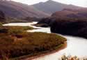
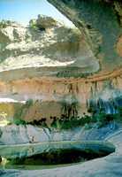
Clear
emerald-colored water, white limestone bedrock and large rock shelters
are a few of the natural features of the Pecos River.
Photo
Courtesy Sandra R. Billingsley |
|
PECOS
RIVER
There's a point on the river where the traveler becomes committed
to the rest of the trip.
That point, for me, is reached at mile six - whether the destination
or just an overnight stop. As a destination, the return trip to
Pandale is a short hike.
Boulders, swift water, sun, heat and isolation ensure only the most
determined and well-prepared canoers make the 60-mile trip through
Val Verde County from Pandale to the new temporary boat ramp near
the Rio Grande.
Canoeing the
Pecos is a test of endurance, patience and perseverance.
Cell phones are useless, roads are primitive and people are few
and far between. But, the challenge is part of the beauty of the
river - knowing that your wit and equipment will hold out until
you're heading back home with the canoe strapped onto the truck.
The last 60 miles of the Pecos offers the spectator an enormous
dose of amazement coupled with an equal helping of humbleness.
High cliffs, rugged scenery and deep bluish/green pools reward the
traveler who has endured many miles of treachery.
Strong winds, which always seem to be blowing from bow to stern,
bottom-scrapping shallows and long, arduous hikes through boulders
rough as the coarsest sandpaper but covered with slick algae make
the going rough.
Underestimating the Pecos can be a mistake as evidenced by wrecked
and sunken canoes. The final mile of the trip is the most nerve-wracking.
The river slows down, the water thickens to runny pudding and the
canoe must glide through silt that runs 40 feet deep.
My husband, Robert Phillips, and I made this trip in September 1999
in a borrowed canoe. The water was about three inches lower and
we left green paint on many rocks.
After that trip, we bought a used canoe and applied six layers of
fiberglass to the hull. This year, we took less equipment but we
brought along Etta, our 10-week-old Catahoula/red heeler mix. Etta
reminded us to stop, drink water and take the river a little more
slowly. This trip wasn't intended to break any records - just a
chance to enjoy an area that's as hard as stone but as sensitive
as a budding flower.
Following is an account of our trip.
|
|
DAY
1
By 10:30 a.m., both trucks are packed and the canoe
is strapped on top of one. After a couple of stops and backtracking
to fetch a much-needed hat, we're finally heading to the Pecos.
We drop one truck near the Amistad takeout at the 60-mile
mark. We
backtrack to our starting point and unload our gear. I drive to
the Pandale Store to tell the manager, Mary Lockridge, that
we're leaving the second truck there
As I'm about to walk back to the river, Lockridge comes out of the
kitchen carrying an enormous, sizzling T-bone steak to a customer.
The memory of that steak sticks with me throughout the 60 miles
of river.
We make a convenient place for Etta on top of two over-stuffed duffel
bags. Plopping her on the cargo, we begin paddling down the Pecos.
Etta's never been on a canoe before. Several times, she slips off
the cargo into the water. Each time, Robert scoops her back up and
returns her to the top of the duffel bags.
The river is three to four inches higher than in 1999 and running
faster, making negotiating the rocks easier.
The ever-present light- to somewhat gusty wind blows in our faces,
forcing us to pull harder on the paddles.
Large mesquite trees along the river create cool pools for bass,
carp, gar and catfish. The trees are pleasant resting spots for
migrating orioles.
Because of the late start, our first day of paddling ends about
three miles from Pandale.
Etta, overcoming her fear of water, jumps from the boat as we begin
to unload the cargo.
As the sun sets, we partake in a long-held tradition - eating our
worst meal the first night with the hope remaining meals will be
better. The dish - we name it "Cajun Spam Surprise" - will indeed
make our other meals seem like gourmet dinners. The highlight of
dinner is breaking out our bottle of whisky, or as we call it "medicinal
medicine."
Bone tired from waking early, packing the trucks, driving more than
230 miles and finally getting on the river, we turn in early to
sleep under the stars.
But, a storm soon encroaches on the starry sky.
Lightening to the west keeps us awake, and the storm overtakes us
at midnight. The thunder quickly intensifies, and the wind scatters
our loose gear. Quickly pitching our tent, we crawl inside. The
Pecos is in an area where rain seldom is seen, but flash flooding
always is a possibility. One rule of canoeing we never deviate from
is camping in an area where we can get to high ground quickly.
Although no rain falls on us, the constant beating of the wind upon
the tent keeps me awake. Etta sleeps soundly, hunkered down in the
sleeping bag.
|
|
DAY
2
Etta wakes early and wants to play. I crawl out of
the tent and set the coffeepot to perking. We eat granola bars for
breakfast and pack the canoe while we wait on the coffee. By mid-morning
we're ready to continue our trip.
Morning hours are the nicest. The river air is cool, and the wind
waits until afternoon to blow.
Slowly floating down the river, the only sounds are the gurgling
of the water being slightly disturbed by the paddles, the cicada's
buzz and the descending trill notes of the canyon wren's call echoing
off the limestone cliffs.
Peacefulness like this can't be purchased in a store.
We pass mile six - our point of no return. From here on,
the slightest mistake will be time consuming, costly and potentially
dangerous.
The sun, straight above us, reminds us to take a lunch break that
consists of beef jerky, dried fruit and chip mix. We wash it down
with Gatorade.
The Pecos continuously changes. One moment we're dragging the canoe
across rocks, the next we're floating through a deep, emerald green
pool. The pool, inevitably, constricts into a narrow passage through
heavy cane - making us feel like we're on the African Queen. Although
many of the passages are shallow, most are floatable with exciting
Type II rapids.
At almost every rapid, we encounter worms clinging like leaches
to the boulders. These creatures secrete a slime that adheres to
our sandals, our legs and even to Etta.
At mile 13, we call it a day. Tonight Robert, who's never
shied from finding new camping foods, makes miso and seaweed soup,
potato pasta with sun-dried tomatoes, tomato paste and jerky. We
chase it with a cup of medicinal medicine.
The tent isn't pitched tonight because there's no evidence of a
storm. The night sky lights up with a billion stars, and we count
satellites instead of sheep to lull us to sleep.
|
|
DAY
3
Etta, once again, greets the day full of energy.
We coffee up and are out on the water early. More than a mile's
worth of boulder garden is waiting on us.
The boulders are scattered across the river at just the right distance
between them to make paddling through impossible. Luckily, this
year, the river's up and maneuverability is better.
At the bottom of the garden we come upon a live fish box with three
koi. The box, which looks fairly new, wasn't here in 1999.
We stop at a cool, refreshing spring to have lunch and refill the
water container. The spring, hidden in a thick stand of cane, bubbles
and gurgles fresh water.
We take no chances and pump the water through a microbiological
filter. Three red-tail hawks glide overhead, probably looking for
their lunch.
The flutes,
or groves in the river bedrock, begin at about mile 15. Gradually
the water begins to shallow until we come to rest on the bottom
of the river surrounded by glaringly white limestone. For the next
two to three miles, we repeatedly get in and out of the boat either
to paddle or to drag the canoe across the flutes.
The spectacular scenery of tall cliffs with rock shelters breaks
the monotony of the work. At one point, we stop, eat some cookies
and look at the cliffs imagining what it must have been like thousands
of years ago when prehistoric people lived in the shelters.
We paddle to mile 20 and camp on a grassy knoll at the confluence
of a canyon and the Pecos. Once again, storm clouds appear above
the cliffs so we pitch the tent.
Tonight's menu is canned chicken with green pesto and sun-dried
tomato bow-tie pasta. Robert can turn the simplest of foods into
something great.
A little medicinal medicine makes our sore muscles feel much better.
We watch the sun set then turn in for the night.
|
|
|
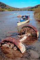
A
wagon axle, which came to rest on the bottom of the river after a
past flood, has become a familiar landmark for Pecos River canoers.
Photo
Courtesy Sandra R. Billingsley |
|
DAY
4
Coffeed up and on the river early, we cruise through
another spectacular part of the river. Throughout the day, we paddle
past extraordinarily high cliffs on our left.
At mile 27, we pass by an old, rusty and extremely heavy
axle with metal rimmed wheels. Just past this landmark, we camp
for the evening in a canyon with several rock shelters.
Tonight, I'm cooking. We're having minestrone soup and, a can of
mixed vegetables, jerky and couscous.
But I don't cook on the portable stove.
I build a small fire to heat fist-size rocks. Once hot, I use tongs
to pick up each rock, knock off the ashes and drop the rocks into
a soup pan of water. The water erupts into a violent boil, but quickly
settles into a rolling boil.
I heat the couscous water the same way, add the couscous, cover
it and let it steam.
As we eat, a fast-moving storm approaches.
We familiarize ourselves with two of the rock shelters just in case
of flash flooding. The tent is pitched with the sides tied to our
equipment.
High winds toss and roll the canoe like a football. Lightning threads
across the sky while thunder shakes the ground and echoes through
the canyon.
Storm number four makes me seriously consider running for a rock
shelter. I feel as vulnerable as a flea in a bathtub.
This storm comes right up the canyon upon us. Even though we're
inside a tent tied to several hundred pounds of gear, the high winds
pick up the tent for a moment.
Lightning, striking the cliffs above us, flashes bright yellow and
red. The thunder and lightning are simultaneous - no counting seconds
to determine the distance. Unfortunately, our medicinal medicine
is outside in the cooler.
Water drains down the side of the canyon and through our cheap tent.
My clothes, backpack and journal become soaked. Etta and I are stuck
lying in an increasingly soggy bed.
Just as I'm ready to grab my canteen and backpack with my hiking
boots and jeans and sprint for the rock shelter, the storm moves
on. Relief overcomes me.
But storm number five swiftly follows number four. Luckily, this
final storm is a bit south of us and not a direct hit.
|
|
|
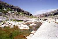
A
large tinaja at Lewis Canyon holds runoff water throughout the year.
The shade offers a cool, confortable place to pump water through a
filter and refill water containers.
Photo
Courtesy Robert A. Phillips |
|
DAY
5
The clear, cloudless morning finds us draping the
soaked tent and bedding over boulders and mesquite trees. Exhausted
from the sleepless night and not willing to go through the effort
of making coffee, we reclaim our scattered belongings and pack the
canoe. Etta watches joyfully.
Lewis Canyon, only 10 miles downstream, is today's destination.
Taking a right out of the canyon, we're faced with several Type
III rapids. The cliffs on the right become taller and the riverbed
widens. The water is shallow as it flows through the flutes, but
it's easy to paddle. Shade from the cliffs cools the riverbed.
Pockets of delicate fern grow alongside sotol, prickly pear and
other Trans-Pecos flora where seeps of water squeeze through the
cliff wall. The canyon wren's descending trills complement the morning
river experience.
In the afternoon, the wind and a couple of mile-long stretches make
our final approach to Lewis Canyon seem to take an eternity.
|
|
|
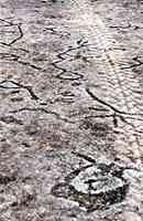
Decades-old
tire tracks still mar petroglyphs at Lewis Canyon. The landowners
are actively conserving the prehistoric artwork for future generations.
Photo
Courtesy Sandra R. Billingsley |
|
The canyon's
claim to fame is a bluff covered with petroglyphs. Hundreds or perhaps
a few thousand years ago, ancient people used rocks to peck the
designs and anthropomorphic figures into the stone. The bluff is
the largest known petroglyph site in Texas.
Prior to the trip, I called the landowner and received permission
to visit the area.
Many years ago, people used to drive across the petroglyphs. Now,
decades later, the tire tracks are still visible. No one is allowed
to drive onto site now.
Marilyn and Howard Hunt, the landowners, recognize the public interest
in the petroglyphs and are actively conserving the site. Several
conservation groups are studying ways to protect the site.
Snapping lots of photographs, we carefully step around the petroglyphs,
the heat up on the bluff is almost unbearable.
|
|
|
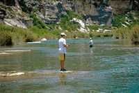
Brothers
Chase and Clay Bradley spend a morning bass fishing down river from
Lewis Canyon. The boys were camping with their aunt and uncle, Jodie
and Jack Baggett of Ozona.
Photo
Courtesy Sandra R. Billingsley |
|
Right before
leaving the site, we meet a couple of lease holders from Ozona.
Jack and Jodie Baggett and their two sons are ending a few days
on their lease camping, fishing and enjoying the cool Pecos water
along with Jack's sister, Joanie Bradley and her three boys from
McKinney.
"It's one of the most beautiful places in Texas," Jack says. "Besides,
there's no water in Ozona and this is close by."
Just about any weekend, several Ozonans can be found fishing, camping
or just spending a day swimming and trying to cool off at Pandale.
This evening,
Robert is again at the kitchen helm, selecting miso and seaweed
soup and hot-and-sour Thai noodles with jerky. The medicinal medicine
helps cool us down after the hot day on the bluff.
As clouds begin building, we pitch the tent. We sleep outside to
enjoy the stars - until sprinkles urge us into the tent.
|
|
DAY
6
The next morning, the canoe's packed and we head
out. Type III and IV rapids and a 20- to 30-foot drop mixed in with
a boulder garden greet us a few meters down river. We step out of
the boat and walk it down.
However, about
a quarter of a mile further we encounter the second largest rapid
on the trip. We stop and scope our route. Three canoe-snagging boulders
are strategically placed about midway in the rapids.
Realizing we're going to get wet or dumped, but always up for a
challenge, we choose the rapid, leaving Etta and the cameras on
the bank.
Before we can begin, we see the Baggetts approaching in two canoes.
Not wanting an audience, I tell Robert we need to hurry and shoot
the rapid. He wants to wait, but I insist on going ahead.
Quickly, the river's current catches us and down we slide. Water
gushing into the rapid on our right pushes us into the last boulder
on the left.
Out we're thrown. Instead of capsizing, the canoe fills about halfway
with water. I laugh all the way down. The canoe slows in the water
below and comes to rest on a gravel bar.
The Baggetts, thinking we're injured, ask if we're OK. We are -
except for a multitude of disgusting worms clinging to us.
We visit with the Baggetts while I pick off worms. Then we say goodbye
and continue. Twenty minutes later, the sounds of the rapid sounds
are left behind.
The trip to today's camping spot is short. We camp at mile 44
on a limestone ledge at the confluence of the Pecos and Painted
Canyon.
I've never anticipated camp food much, but Robert's dinners are
good or at least interesting. He cooks miso and seaweed soup again
and chicken with couscous and ranchero sauce. We're almost out of
medicinal medicine, so we have to go sparingly tonight.
The tent goes up but we sleep outside to enjoy the stars.
|
 |
|
DAY
7
We take time this morning to hike along the river.
Although we rarely see people on the river, each morning and almost
every evening we hear the buzz of a small plane we figure belongs
to the Border Patrol. The pilot has never flown the plane where
we can see it.
Today, we see the plane. Just as I am lifting my camera for a shot,
the plane ducks behind the top of the bluff. Kind of an irritating
pest.
Our goal today is the Pecos River High Bridge.
We enter Amistad Reservoir immediately after leaving Painted
Canyon. The water begins to get murky.
Here the river makes a dramatic bend at Shumla Bend. Dozens
of rock shelters look out over the river.
The weir dam, where many canoeists end their trip, is running about
six inches above the dam - three inches higher than in 1999.
We carefully guide the canoe down the weir with a rope. The dam
also marks the difference between the natural beauty of the untouched
Pecos River from Pandale and the damage created by Amistad Reservoir.
Although multiple-story size boulders are scattered about the river
to make it beautiful, the silt deepens and non-indigenous vegetation
begins to crowd both sides of the river.
Hydrilla, a non-local water plant, is clogging parts of the Pecos
and makes paddling through difficult. Silt also becomes so deep
that only a few inches of water clear below our canoe.
Cane and salt cedar, while good for migrating birds, have choked
the river, created islands and clogged canyons.
Just before the Pecos River High Bridge, the water turns
almost blood red and smells unpleasant. We think it must be an algae
bloom.
Paddling to the downside of the bridge, we think camping under the
bridge would be fun. But once the train roars across, we get back
into the canoe and go another quarter mile or so.
We find a grassy knoll and pitch our tent because clouds are building
to the south. Thinking this could be another intense storm, we anchor
the tent to the boat and equipment.
For our last night, Robert makes a delicious beef jerky chili with
red beans and rice. We drink our last bit of medicinal medicine.
Once again, we're battered by several storms. Fortunately, the brunt
seems to go more to our west.
|
|
DAY
8
I want to get up early so we can paddle the last
four-and-a-half miles before the afternoon winds pick up.
Our biggest fear is the mile just before the U.S. Highway 90 bridge.
The silt becomes 40 feet deep and at times the stern of the boat
bumps on the silt. We become very still as if we're holding our
breaths for fear of disturbing the canoe and sending it out of the
channel and into the silt. Although the river doesn't appear to
have a main channel, the current does carry us along. Finally, we
reach the Highway 90 bridge and breathe a sigh of relief. Past the
bridge, the water deepens to about three feet.
We know we're home free.
We have a sad but invigorating feeling. It's sad because we know
the trip's over. But, it's exciting because we feel that, once again,
we've met the challenge of the river without getting injured. Robert
walks up to our friend's place and drives his truck down to the
locked National Park Service gate at the ramp so we can load our
gear.
After 60 miles and a week, I'm still thinking about that T-bone
steak at the Pandale Store. We drive there, order beer, steaks and
fresh Gulf shrimp.
Mary, the manager, brings us two huge stakes. Somehow I eat my entire
steak.
During the drive home, I give Etta the bone. She cleans it up.
|
|
Epilogue
The Pecos River is one of the last pristine rivers
in Texas. About 100 people a year leave Pandale to attempt the challenge
of the river.
Some don't make it as evidenced by broken or sunken canoes along
the way. Some become fed up and walk out. Many pull out near the
weir dam. Those who experience the Pecos' final 60 miles develop
a respect, appreciation and protective feeling for the river.
For thousands of years, the Pecos River has been home to people
who hunted and gathered or ranched along its banks. It shouldn't
be an easy river.
Perhaps by silting up the river and reducing human access, Mother
Nature is trying to protect the Pecos.
|
August
2001
Article originally published on July 15, 2001 in the San Angelo Standard-Times.
Republished with permission.
Photographs courtesy of Sandra R. Billingsley and Robert A. Phillips.
More
on Pecos River
Texas Towns
Texas Trips |
|
|