|
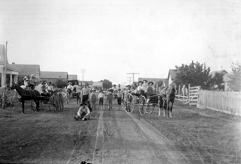
DeSoto, Texas
in 1911
Click on image to enlarge
Vintage photo, Wikimedia Commons |
History
By Clint
Skinner
Boasting a population of 49,047 within its 21.6 square miles, DeSoto
lies twelve miles south of Dallas
on the outer edge of Dallas
County's southwestern region. Duncanville
resides along the northwestern border, Glenn
Heights runs along the south, Lancaster
holds the east, and Cedar
Hill hugs the west. These neighbors, with the exception of Glenn
Heights, combine with DeSoto to form what is called The Best
Southwest, claiming a grand total population of 168,960 in the year
2010. Despite its size and prosperity, DeSoto started out very small.
Curtis and Amelia Parks first settled the area in 1847. The couple
from Indiana were soon followed by Thomas Cheshier, Zebedee Heath,
William Caldwell, T. Rhodes, F. M. Hamilton, Allen Q. Nance, Otway
B. Nance, and John P. Rhodes. The following year in 1848, T. J.
Johnson arrived from Tennessee and built the first general merchandise
store. Located at the intersection of Belt Line Road and Hampton
Road, it was simply called The Store by locals. It did not take
long for the town to develop around it. Sometime during the 1870s,
the store was accompanied by a harness shop established by S. E.
Judah.
The year of 1881 brought with it the establishment of a post office.
The citizens named it DeSoto to pay tribute to Dr. Thomas Hernando
DeSoto Stewart, a popular physician who had dedicated a considerable
amount of service to the community. Four years later, the town had
120 residents. In 1898, Judah's son built a general store, offering
competition with Johnson's business. Nothing much happened afterward,
mainly because DeSoto was an agricultural town. By 1930, it had
only seven businesses and ninety-seven people. This would change
during the next decade.
The end of World
War Two sparked a massive increase in the town's population.
Unfortunately, the water distribution system proved inadequate to
support the influx of residents. Officials determined that incorporating
the town would solve the problem. On March 2, 1949, they held an
election. The measure passed with fifty voting "yeah" and two "nay".
DeSoto became an incorporated city the next day. Wayne A. Chowning
served as the first mayor and worked with a city council of five
alderman to run the local government. The first meeting took place
on March 17th at a schoolhouse located on E. Belt Line Rd.
A year later, the 1950 census showed that the population has reached
three hundred. The size of grew to fifteen square miles, thanks
to a series of annexations. From 1956 to 1962, the local high school
was located at 200 E. Belt Line Road. A population of 1,969 in 1960
prompted the school to move to a new location further down the road.
However, it did not last long. Seventy-one businesses and a population
of 6,617 prompted a bond election in 1973 to fund the construction
of new high school, which would be located on Eagle Drive. The following
year, on October 26th, the citizens narrowly approved the acquisition
of an incorporated town called Woodland Hills. It was located northwest
of DeSoto and had 366 residents living in the area. DeSoto High
School opened its doors during 1976, abandoning the old site which
would later become DeSoto East Junior High.
In 1980, the city boasted a large population of 15,338 that was
being served by 168 businesses. The number of companies more than
doubled over the next four years. In February 1986, a group of businessmen
led by Pierce Monkeres opened the Bank of DeSoto. Upon its establishment,
Monkeres became the CEO and worked hard to ensure that the financial
institution played an important part of the community. The Focus
Daily News began publication the following year. Owned by Publishers
Newspapers, it provided information on local stories and events
throughout Dallas
County. It currently serves as the officially newspaper of DeSoto,
Duncanville, Lancaster,
Cedar Hill,
and Glenn Heights. It has
the largest circulation in Texas among the many suburban daily newspapers.
The population reached 30,544 during 1991. To help with overcrowding
in the school system, a campus opened next to DeSoto High School
in 1997 to handle all the ninth graders. The city celebrated its
fiftieth anniversary in 1999 and boasted a population of 37,646
a year later. It had one police station, one library, three fire
stations, ten public schools, 37 parks, and 1,203 businesses.
|
Things to Do
1) The Nance
Farm : Designated as a Texas historical landmark in 1976, the
Nance Farm can be found at 1325 Greenbrook Drive. Otway Bird Nance
built it in 1851 on 640 acres he had bought from the Peters Colony
Land Grant. He arrived from Illinois with his wife and ten children.
Once he settled down, Otway successfully doubled the size of his
farm during the course of several years. The main house was originally
a two-story home designed using the Greek Revival style. The place
was remodeled to fit the Victorian style sometime before 1883. The
Nance Family lived at the farm until the middle of the twentieth
century.
From the 1950s to the 1970s, the farm acreage was divided up and
sold for residential development. The City of DeSoto bought the
house in 1975 and used it as a community center. However, the city
sold the property to a private citizen six years later. The house
was later in danger of being foreclosed. The City of DeSoto stepped
in and saved it in 2007. By then, the property had been reduced
to two acres.
2) The Roy Orr Trail : The Roy Orr Trail runs a total of
3.6 miles along Ten Mile Creek from the city's western border at
Mirkes Parkway to the eastern boundary at Murphy Hills Park. The
trail was originally two separate treks. One went from Westmoreland
Road to the Town Center while the other went from Polk Street to
Murphy Hills Park. In 2001, the city council approved a measure
to connect the two pieces. The new trail was named after an influential
man named Ray Orr.
Born on October 2, 1932, Roy Lee Orr spent his whole life in DeSoto.
He served during the Korean War working for the Air Force, then
returned to become a successful businessman in the insurance and
banking industries. He co-founded banks in DeSoto and Red Oak and
became the chief executive officer of First National Bank Red Oak.
In 1963, Roy helped with the drafting and passage of the charter
for the DeSoto Chamber of Commerce. He was then elected as mayor
because of his business success, tenure as the president of the
DeSoto School Board, and early service as a volunteer fireman among
other factors. While doing his duties as mayor, officials appointed
him to the Dallas County Commissioners Court, where he served for
ten years.
Throughout his life of public service, Roy Orr was elected to the
National Association of Counties, DeSoto Chamber of Commerce, Oak
Cliff Lions Club, Texas Research League, Advisory Board of Abilene
Christian University, Board of the Medina Children's Home, and the
Executive Committee of the Circle Ten Board of the Boy Scouts. He
helped state governors Dolph Briscoe, Mark White, and Bill Clements
by working for various boards and commissions including the Texas
County and District Retirement System Board, Texas Commission on
Jail Standards, and Texas Aeronautics Commission. Governor Ann Richards
appointed him to the Texas Alcoholic Beverage Commission, a position
which he held for six years. On the national level, Roy Orr served
Jimmy Carter's Board of the Advisory Commission and Ronald Reagan's
Advisory Committee on Federalism.
3) Windmill Hill Nature Preserve : The Windmill Hill Nature
Preserve covers 75 acres of land set aside by Dallas County and
the City of DeSoto. It is located near the intersection of Duncanville
Road and Wintergreen Road. In addition to its twelve nature trails,
the preserve has a bridge which is named in memory of musician Stephen
Ray Vaughn.
4) DeSoto BMX : Grimes Park at 500 E. Centre Park Boulevard
serves as the home of the DeSoto BMX. The building became the first
covered BMX track in the United States.
|
Bibliography
Bankdesoto.com
City-data.com
Dallasnews.com
Desototexas.gov
Dfwtrailguide.com
Livability.com
Tourtexas.com
Tshaonline.org
Wikipedia.org
|
| Texas
Escapes, in its purpose to preserve historic, endangered and vanishing
Texas, asks that anyone wishing to share their local history, stories,
landmarks and vintage/historic photos, please contact
us. |
|
|