|
Today
we think nothing of stepping into our vehicle, driving at 70 mph,
along paved highways, eating at roadside restaurants, staying at nice
motels, having a choice of service stations and traveling 500 miles
or more in a day. It is a snap.
Not so long ago, a journey such as this was different matter altogether.
Before automobiles, highways, motels and cafes, this type of journey
would have required extensive planning and preparation before the
attempt.
First, let us examine the area to be traveled.
A study of the actual mileage exhibited in a map of the Texas
Panhandle, No Man's Land, the Western Indian Territory, the Cherokee
Outlet, the Cherokee Strip and the southwestern section of the State
of Kansas, drawn in the year 1880, bring travel at that time into
focus.
Keep in mind now, the conveyances at this time were travel by horseback,
covering 20 to 40 miles per day, travel by buckboard or buggy, 15
to 25 miles per day, or wagon, usually 15 miles per day average, that
is if all went well, the weather held and no breakdowns.
Let us suppose we lived in Old
Tascosa and decided to make a trip to Dodge City, Kan. The trail
length in 1880 was 240 miles. By horseback, it took eight days if
you hurried. By buggy it required 12 days with no bad luck. By wagon,
be prepared to spend 15 to 16 days on the road. By "being prepared"
I mean you should have food for both man and beast, shelter from the
elements, and carry some protection from anyone meaning you harm.
By the way, a loaded freight wagon hauling from Dodge to Tascosa
required a full month to complete.
Along the way, you would pass Little Blue Station, Zulu Stockade,
Central City, Beaver City, Meade, Fowler, Dugan's Store and, finally,
Dodge City.
Remember, these places were not towns with accommodation, but mostly
buffalo hide-covered soddies known more for their whiskey served rather
than way-stations for travelers. |
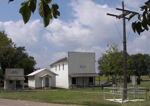 |
| "Near the
jail museum are several buildings from Old
Mobeetie along with a wooden flagpole, the last surviving remnant
from Fort Elliott." - Terry
Jeanson, September 2007 |
How about a
visit to Ft. Elliott
and Old Mobeetie? From
Tascosa to
Mobeetie on Sweetwater
Creek was 100 miles without a single inhabited dwelling along the
way. Better be prepared.
Let us travel from Mobeetie
to Dodge City, a distance of 286 miles by trail. You crossed into
Indian Territory, crossed the Cherokee Outlet, the Cherokee Strip
before reaching Dodge City.
You could stay at Polly's Hotel, a questionable abode, Buzzard's Roost
or Camp Supply before the last leg of the journey - 100 miles of open
Kansas prairie. Don't worry about getting lost, as all trails were
plainly marked unless you got caught in a blizzard. The camping areas
were easy to find, most with good water and firewood.
But, there was always the chance of meeting Indians off the reservations,
outlaws looking for an easy target, weather of all dimensions, flooded
creeks and rivers, runaway teams, stampeding herds and the many trials
of human expectations.
All these things were considered challenges of everyday life in that
time, but without the advantages of a cellphone of course. So, Bon
voyage, hasta la vista and goodbye until we see you again. That is,
if you make it!
� Delbert Trew
"It's All Trew" April
26, 2011 column |
|
|