|
THE
QUEST
Searching for
the
Pulaski Historical Marker
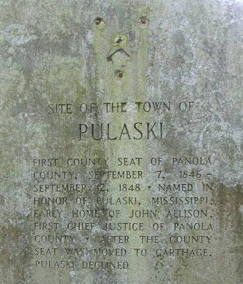
Pulaski
First Panola County Seat
September 7, 1846 - September 12, 1848
By Barclay
Gibson |
| Where
to start describing how I visited the five foot tall granite 1936
Panola County Centennial Historical Marker for the defunct town site
of Pulaski, former seat of Panola County? Here I am safely back in
Carlsbad, New Mexico, re-reading Ruthie's directions to the marker.
By way of explanation, Ruthie C, a septuagenarian retired Army Colonel
who resides in San Antonio,
is a trailblazer of the first order in locating these
old historical markers. She did a lot of work hunting them down
long before the current drive to inventory, locate, inspect, and photograph
all these uniquely beautiful granite markers. Over one thousand of
them were placed all over the state way back in 1936 in celebration
of the Centennial
of Texas' independence from Mexico.
An awful lot of money and work went into planning, cutting, engraving,
transporting and installing the 1,500+ pound granite slabs. The placement
of these landmarks may have made a lot of sense back in 1936, but
here we are over seventy years later and a lot of them are way, way
off the current beaten track. After the project was finished, that
department was closed and the markers
largely forgotten about until just recently. Some have been moved
due to development, more than a few vandalized, some lost due to incorrect
placement, and some have been stolen. I have an idea some have even
been disposed of in fills for interstate highway overpasses. And believe
me, just because Ruthie was able to not only locate a marker but to
actually get to it doesn't mean just anyone else is up to the task. |
 |
I've
thought about how to tell my story for several months now. What Ruthie
wrote about how to find the marker may be correct, but meanwhile,
there are a whole lot of blank spaces to be filled in along the way.
Quoting from her notes for visiting the Pulaski Marker: ". . . After
going thru a cattle guard stay left at the Y. You will come to a cleared
area for a pipe line, go left and follow the pipe line, cross fence,
and follow it to the right, Marker is in a clearing on your left,
There is some sort of a target near the marker."
So, let me start at the beginning. This tale is going to take a while,
so, relax, get a cup of coffee, and ease back in your favorite chair.
You may doze off a time or two, but that's okay because I am enjoying
reliving my visit to the Panola County Pulaski Centennial Marker.
To say this marker is off the beaten path is somewhat of an understatement.
Sometime back in February I started planning a trip to see my friend
and fellow TexasEscapes.com contributor,
Gerald Massey, who
lives in Shreveport, Louisiana. After visiting him, I wanted to see
all the 1936 Centennial Markers I could on the way back home. First,
Panola County, then Harrison, Upshur, Smith, Wood, Anderson, Navarro
and Hill Counties. Just a few (40+) markers, don't you see. Anyway,
back to my story. I talked with several people in Carthage,
County Seat of Panola County, about seeing the Pulaski Marker. None
had seen it themselves and few had ever even heard of it. Finally,
I was given the phone number to the land owner on whose property the
marker is located.
I called him up. He was very friendly and told me that the marker
was, indeed, on his property but that he had not seen it in over 35
years! It was way back in the brush right close to the Sabine
River. He said, "I'm not a gonna cross that pipeline." With the
recent rains, I pictured a huge mud and slosh filled ditch. He said
it was very hard to get to by going through his property, and that
I had best call his neighbor and get access that way. His neighbor
said that his land had been reseeded several years ago by a forestation
company, and the undergrowth was so bad that he didn't think you could
get to it from his land either. I called the first guy back, and he
was still very hesitant to take me to the marker. One thing led to
another and the time to leave for Louisiana was at hand. I would have
to 'wing' it.
After visiting Gerald, I left Shreveport on Thursday morning, April
22nd. I ate a delicious breakfast at, of all places, the Petro Iron
Skillet Truck Stop outside Shreveport. I then dropped southwest on
US79 to see the Bethany
Centennial Marker just inside the Texas State Line. Following
Ruthie's directions, I located the unpaved Panola County Road and
proceeded west with her notes in hand.
I
came to the "cleared area for a pipeline." Here
is where you have to start filling in the blanks. The blank space
between the word 'area' and the word 'for' is about two miles of back
country, overgrown, uncivilized, desolate roads, undergrowth, thorns,
and thistles. But I'm getting ahead of myself. When I came to the
clearing, there was a locked gate. Some hunting club uses the property
and has restricted access. I parked my truck so as not to block the
road. Since it was still early in the morning, the dew was very heavy.
I put on my boots, got Ruthie's notes, grabbed my camera, and climbed
through the fence. I even took a black and white print out of Ruthie's
picture of the marker to give me an idea of its surroundings. I didn't
know that I was filling in the blanks, so I expected a pipeline close
by. I walked all over that area, all around the perimeter of the clearing
as far away from the truck as I dared, and still didn't find anything.
I must have read those notes 20-30 times. Complex directions always
read different when you are on location. I looked left, right, and
for another clearing. Nothing. I imagined seeing the marker in clumps
of trees, in a pasture, and back in the woods. Still nothing. |
 |
Back to the truck
I went. I read the directions again just to make sure I hadn't missed
something, I turned around, and headed back down the road to civilization.
Here came a pickup. I waved it down, grabbed a picture of a similar
gray Centennial Marker, and asked the man if he had ever seen the
Pulaski Centennial Marker. He just grinned and began telling me how
hard it was to get to. Turns out he was the nephew of the neighboring
land owner that I had talked to. He told me it is quite a walk through
thick undergrowth. I smiled and said that I was prepared for that
adding, "I really want to see this marker." He said, "I'm not gonna
go there but follow me and I'll show you how to get to it."
He unlocked the gate and proceed far past the hunting lodge. We wound
around for maybe two miles (filling in the blanks) where he turned
off to the "left and follow(ed) the pipeline road" for about 100 yards.
He stopped and pointed straight off the road. He said that the first
part is thick with undergrowth, the reseeded forest, and at the property
line, when it begins to thin out, is the old growth. The marker is
right there. "Follow this fence line and it will lead you right to
it."
I saw that my cell phone had no signal and joked to him that if my
truck was still there in a couple of days to come looking for me.
He told me that he would not be back in that area for two weeks. Just
in case he left before I did, he was kind enough to give me the combination
to the lock so I could get out. |
 |
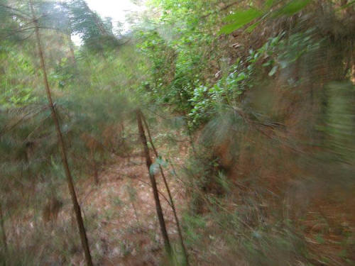
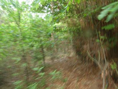
| "Right away
I was besieged with thistle, thorn bushes, and clingy vines concealing
all kinds of unfriendly critters." - Barclay
Gibson |
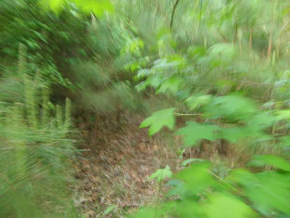
| "It must
have been close to 1/4 mile when the undergrowth began to thin."
- Barclay
Gibson |
| Seeing that it
was going to be tough going through that thicket which was easily
15 to 20 feet high, I took only my camera. Right away I was besieged
with thistle, thorn bushes, and clingy vines concealing all kinds
of unfriendly critters. It must have been close to 1/4 mile when the
undergrowth began to thin. Just as he said, the marker was right there.
Relieved that I had actually found it, now my only thought was to
get some pictures of the marker and find my way back. |
| "Relieved
that I had actually found it, now my only thought was to get some
pictures of the marker and find my way back." - Barclay
Gibson |
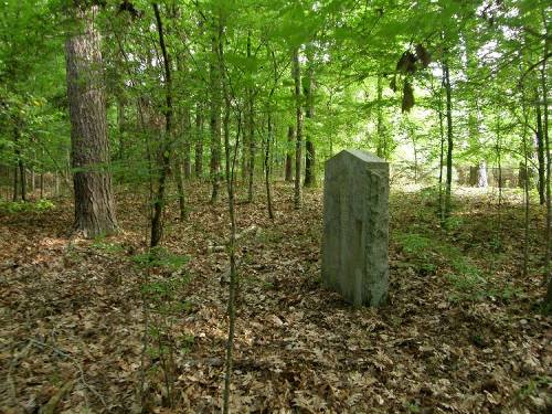
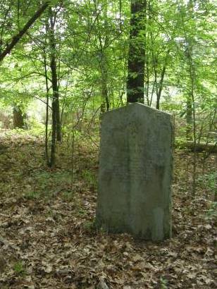
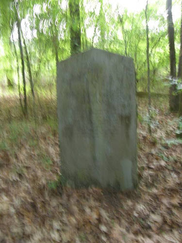
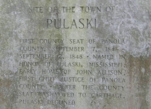
| "The five
foot tall granite 1936 Panola County Centennial Historical Marker
for the defunct town site of Pulaski, former seat of Panola County."
- Barclay
Gibson |
| "I should
have taken just a few more seconds to take better pictures" -
Barclay
Gibson |
In
hindsight, I was in such a hurry to get back to the truck and civilization
that I didn't realize how much the sun was shielded for photography.
I should have taken just a few more seconds to take better pictures,
really look around, and maybe even go a few hundred more yards to
the bank of the Sabine River but my only thought was OUT.
I was just glad to get back to the truck in one piece. My arm and
hand were bleeding from the barbs and scratches. I must have followed
the fence line, but I never saw it the whole time. It couldn't have
been twenty feet away. The time/date stamp on my pictures show that
I was gone from the truck less than 15 minutes. It seemed like over
an hour.
On my way out of the property, the gate was still unlocked so I left
a card telling the man, I don't even know his name, thanks for the
help and for the directions. So, what is the location of the marker?
I could give you my GPS readings but there are a whole lot of blanks
to fill in between where you are right now and where that marker is. |
 |
This little narrative
might tell you how I found the 1936 Panola County Pulaski Centennial
Marker but it doesn't come close to telling you why I wanted to see
it. I'll let you know as soon as I find out myself. I asked my wife
to read this story before sending it in. Her only comment was that
she thought I needed to go back to my old hobby of stamp collecting.
Now that would give me a lot of chances to 'fill in the blanks.'
© Barclay
Gibson September 2010
See Barclay Gibson's
Texas
More Texas Centennial
|
| Texas
Escapes, in its purpose to preserve historic, endangered and vanishing
Texas, asks that anyone wishing to share their local history, stories,
landmarks and vintage or recent photos, please contact
us. |
|
|