|
|
Since
1892, a four-span steel bridge resting on stone supports had extended
across the Llano
River to connect the northern and southern sides of the small
county seat town that shared the river's name.
The structure amounted to an impressive piece of engineering for its
day, but when heavy rain began pouring down upstream from the bridge
in the Hill Country
on June 14, 1935, the figurative clock started ticking toward the
moment of its destruction. That came on the following morning, when
the Llano
River crested at 41.5 feet, its highest level in known history.
Frothy, chocolate-colored water roaring down a normally shallow stream
swept away three of the bridge's four spans. |
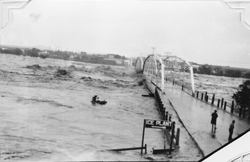
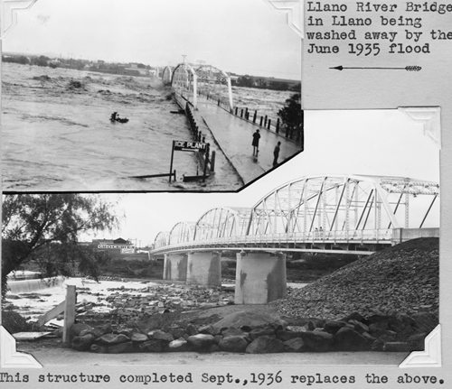
Llano River
Bridge in Llano
being washed away by the 1935
flood
Photo
courtesy TXDoT |
"Friday's Flood
Washed Out Bridge," the weekly Llano News reported on June 20. "The
river began to rise at about 8 o'clock in the morning [of Friday,
June 15]," the lead article related, "and continued to rise steadily
until the bridge had been taken out."
Of course, the flood did much more than wipe out the Llano River bridge.
It destroyed two smaller bridges on the Llano, including one at the
old German-settled community of Castell.
When the surge moved from the Llano to the Colorado, it also washed
out the bridge at Marble
Falls. Then the water rushed onward to Austin,
where it spared-barely-the Congress Avenue bridge that was then the
river's principal crossing in the capital city. Even so, the flood
waters covered the bridge for a time, isolating north and south Austin. |
 |
|
Elsewhere in
the state, heavy rain triggered major flooding along the Nueces
and Guadalupe rivers.
Back in Llano,
the flood not only cut the town in half, it left parts of town with
no electricity, drinking water or commercial ice. On top of all
that, Llano
had no means of contact with the outside world. While hard to believe
given today's instant communication channels, more than 24 hours
passed before someone was able to make it to Fredericksburg
to report the extensive damage in Llano.
The Llano-Colorado river flood claimed the lives of eight people,
including a man who died just doing his job.
High water had taken down the only telephone line between Llano
and Austin at a point
where it crossed the river about 12 miles downstream from Llano.
The Monday following the flood, C. L. Gunderman, a 35-year-old lineman
for what was then Southwestern Bell Telephone Co., drowned in the
Llano
when still fast-moving water capsized a boat he was in. He had been
working with other phone company personnel to get the toll line
back in operation. When the Llano News went to press two days later,
Gunderman's body was still missing.
In addition to the loss of lives (statewide at least 24 people died
in weather-related incidents) and damage to property in that Depression-era
flood, 3,000-plus pecan trees along the Llano River were uprooted
by the flood. That caused significant economic harm to landowners
who made part of their living selling nuts harvested on their river-front
acreage.
Meanwhile, workers from the state Highway Department (now Texas
Department of Transportation) were busy building a temporary, low-water
bridge to reconnect Llano
and get State Highway 16 back in service. A permanent bridge was
not completed until September 1936, lightning speed compared with
highway construction projects today.
Wider and higher than the original bridge, that now 82-year-old
bridge survived the recent devastating Llano-Colorado River flood,
the worst flood along the two streams since the 1935 event.
|
 |
A report prepared
in 1937 by the Austin-San Antonio office of what is now the National
Weather Service noted that, "Timely warnings were issued for these
floods, and large amounts of property saved thereby�.However, loses
were heavy, especially to bridges and highways." Back then, those
warnings would only have come via commercial radio broadcasts or teletype
messages.
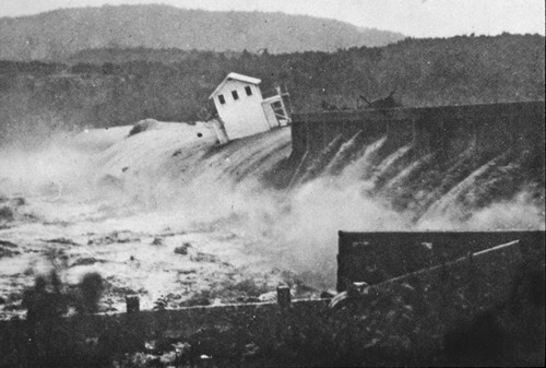
Central Texans had realized for years that the only way to lessen
the impact of the periodic torrential rains that turned Hill Country
rivers and streams into deadly torrents would be a dam or series of
flood control dams on the Colorado. The Lower Colorado River Authority
had been created earlier that year, so while the June flood did not
inspire the construction of the dams that resulted in the Highland
Lakes chain, the disaster certainly gave the project impetus.
Within three years of the flood, dams had been completed or were under
construction at three points along the Colorado-Buchanan
Dam, Mansfield
Dam (Lake Travis) and Tom
Miller Dam (Lake
Austin). During their extensive live coverage of the latest major
flood, Austin's television
stations as well as its daily newspaper all compared the event with
the 1935 disaster and noted that the LCRA's dams and the lakes they
formed had done much to tame the two rivers. But as KXAN's longtime
weathercaster Jim Spencer pointed out during the flood, "Mother nature
is never going to be completely tamed." |
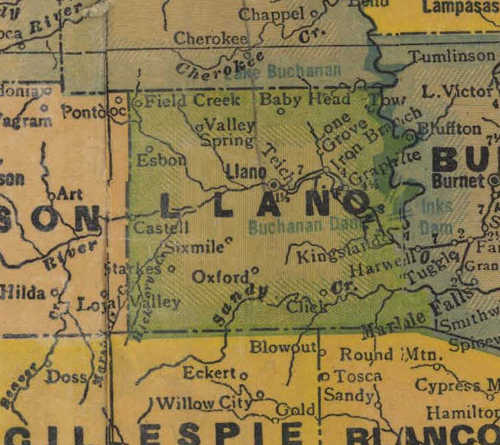 |
1940s map showing
Llano
River coursing through Llano
County
From Texas state map #4335
Courtesy Texas General Land Office |
|
|