|
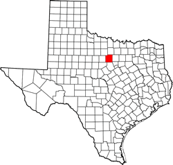
Palo
Pinto County
|
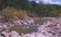
Brazos
River
TE photo |
Palo
Pinto County is nearly 1,000 square miles and the entire county population
is only 25,000. People from the Austin
area can see there are hills outside the Hill
Country and Texans from below Waco
will marvel at how clear and scenic the Brazos River is north of Mineral
Wells.
Detailed brochures and maps are available for Lake Mineral Wells (actually
in Parker County although it's owned and managed by the City of Mineral
Wells), Possum
Kingdom Lake and Lake Palo Pinto. |
Palo Pinto
County - A Brief History
Palo
Pinto County was established in 1856 from Bosque and Navarro
Counties with Golconda as its county seat. The name was
changed in 1858 to Palo Pinto. In 1850 there were still 1000 Indians
living along the Brazos River and corn was the county's main crop.
The railroad (Texas and Pacific) came through southern Palo Pinto
County in 1880. 1891 saw the Weatherford
and Mineral Wells and
Northwestern Railway completed. Fort Wolters (now the Mineral Wells
Industrial Park) was originally a National Guard training facility
in 1925 and during WWII
became an infantry training camp. It became an Air Force Base for
a few years in the 1950s and then became Army property again, this
time for helicopter pilot training. The fort closed permanently
in '73.
Ghost Town Thurber - Trip Part 5 ›
|
|
|