|
|
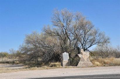
Texas state line
marker and "Compromise of 1850" marker
On Hwy 18 N of Kermit
Photo courtesy Gerald
Massey, November 2009 |
History in
a Pecan Shell
Cheyenne
had no 19th Century history. The town that was to become Cheyenne
was originally part of the W. F. Scarborough Ranch. In the
mid 1920s an oil discovery was made and was named after the ranch.
The Scarborough Field came in 1927 and the optimistic residents of
Winkler County built crude housing in anticipation. A school was planned
but never (thankfully) built. A post office opened in 1929. In the
fickle world of boom and bust towns, Cheyenne was briefly eclipsed
by an upstart town named Leck. This town was also named after
an oil field and fared even worse than Cheyenne, disappearing entirely
within a few years.
Cheyenne�s post office was moved to the recently-arrived Texas-New
Mexican Railroad by Mr. Scarborough and the town seemed to have been
given a second-chance. A larger building was constructed for a store/
post office and this structure was joined by a few houses and a handful
of fledgling businesses.
The Great Depression was in full swing and by the end of the decade,
only a single business remained open. The population was reportedly
a mere 25 on the eve of WWII
and the railroad abandoned its shipping pens in the early 1940s. The
final nail was driven in Cheyenne�s coffin when the post office closed
in 1944. |
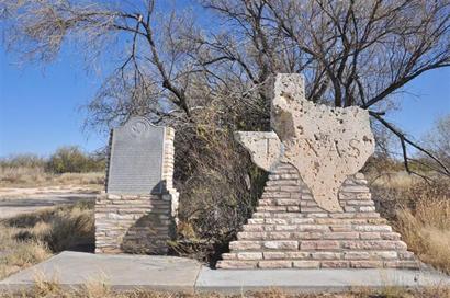 |
"Compromise
of 1850" historical marker & Texas state line marker
Photo courtesy Gerald
Massey, November 2009 |
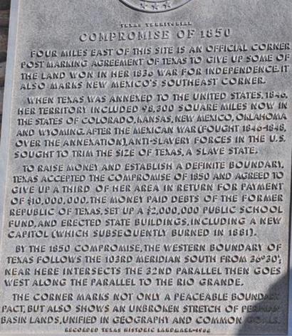
Historical
Marker Text
Texas Territorial
Compromise of 1850
Four miles east
of this site is an official corner post marking agreement of Texas
to give up some of the land won in her 1836 war for independence.
It also marks New Mexico's southeast corner. When Texas
was annexed to the United States, 1846, her territory included 98,300
square miles now in the states of Colorado, Kansas, New Mexico, Oklahoma
and Wyoming. After the Mexican War (fought 1846-1848, over the annexation),
anti-slavery forces in the U. S. sought to trim the size of Texas,
a slave state. To raise money and establish a definite boundary, Texas
accepted the compromise of 1850 and agreed to give up a third of her
area in return for payment of $10,000,000. The money paid debts of
the former Republic of Texas, set up a $2,000,000 public school fund,
and erected state buildings, including a new capitol (which subsequently
burned in 1881). By the 1850 compromise, the western boundary of Texas
follows the 103rd meridian south from 36* 30'; near here intersects
the 32nd parallel, then goes west along the parallel to the Rio Grande.
The corner marks not only a peaceable boundary pact, but also shows
an unbroken stretch of Permian Basin lands, unified in geography and
common goals. |
1850
Compromise Marker Post
Photographer's Note:
It is on the Texas-New Mexico border, Highway 18, about 50-miles south
of Hobbs, NM, near Cheyenne, Texas. Google Maps and my Street Atlas
map both show a road, Ranch Road-1218, going north of a town, Magwalt,
Texas. Only a couple miles north from the town. It also shows going
right by that corner so, locating or trying to locate that "Marker
Post" (see first line of historical marker text above) should
be relative easy. - Gerald
Massey, November 2009
See Ghost Counties
of Texas |
Texas Territorial
Compromise of 1850 historical marker
Photo courtesy Gerald
Massey, November 2009 |
1940s Winkler
County map showing Cheyenne N of Kermit
(Above "N-K" in "W-I-N-K-L-E-R")
Courtesy General Land Office |
| Texas
Escapes, in its purpose to preserve historic, endangered and vanishing
Texas, asks that anyone wishing to share their local history, stories,
landmarks and vintage/historic photos, please contact
us. |
|
|

 Texas
Gulf Coast
Texas
Gulf Coast East
Texas
East
Texas Central
Texas North
Central
Texas North Central
Texas South
Central
Texas South Texas
Panhandle
Texas
Panhandle South
Texas
South
Texas Texas
Hill Country
Texas
Hill Country West
Texas
West
Texas Texas
Ghost Towns
Texas
Ghost Towns Texas
Counties
Texas
Counties