|
‹ Barton
Springs, page 2
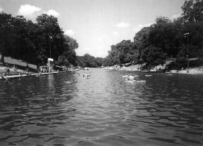
The
floor of the pool is made of limestone and Buda gravel mixed with
clay, which acts like cement. There are three general sections to
the pool. The wading area extends from the upper dam all the way to
Bedicheck's rock where it drops off steeply to sixteen feet. This
is where the diving board is located over the main spring. The area
between the diving board and the lower dam is deep, from ten to sixteen
feet. There used to be a high dive in this section but it was removed
in the 1970s. The strip on the north side of the pool from the lower
dam to the lifeguard stand near the entrance is about four feet and
has a gravel bottom. It was once used as a lap lane. Lap lanes are
not designated at Barton Springs but lap swimming is very popular.
Serious swimmers hit the pool early in the morning to avoid the crowd
and have an unspoken agreement about how to divide up the lanes. Some
swim between the sidewalks, while others prefer to swim the whole
length. Since the 1930s there has been an informal policy of leaving
the front gate closed but accessible to early bird swimmers, but recently
an iron fence with a lock was put in to keep children from entering
unattended and to comply with city codes. |
 |
| Large pecan and
cottonwood trees provide plenty of shade and either side of the pool
is surrounded by grassy slopes. During the peak summer hours it can
get very crowded, with the teenagers hanging out on the east slope
and everyone else on the flatter west bank. Floats are allowed only
in the deepest section near the dam. You can still sunbathe nude inside
the women's dressing area on a few grassy areas that are open to the
sky, but it is an unwritten policy. |
 |
The Polar
Bear Club at Barton Springs, which has over one hundred members,
swims year-round. One member, Jill Carr, swam in such cold weather
that her hair froze when she exited the water!
The Barton Creek Greenbelt officially opened in 1985. It
is a 7.8-mile trail for hiking and bicycling. Several swimming holes
dot the trail. Rock climbers also practice on the limestone cliffs.
The trail is rocky and semi-primitive and cuts through scenic wildflowers,
trees, limestone cliffs, caves, meadows, swimming holes and waterfalls.
The trail varies from narrow ledges to wide walkways. Wildlife is
abundant in the park. Hiking in the Greenbelt will really give you
the feeling of being far away in the wilderness, not in the middle
of the city, which it really is. The trail extends from Zilker
Park to Lost Creek, with a trailhead at Zilker
Park just west of the pool. You can also access the trail where
Spyglass intersects with Barton Skyway; behind Barton Hills Elementary
School on 2010 Homedale Drive; at the Gus Fruh Access at 2642 Barton
Hills Drive; at Loop 360 near the office buildings behind Brodie Oaks;
and at Camp Craft Road at the intersection of Scottish Woods Trail.
The Loop 360 and Gus Fruh sections are wheelchair-accessible. Dogs
are permitted on leash only. For up-to-date trail conditions, call
472-1267.
A new trail is being built that will connect Southwest Parkway
with the Greenbelt at the MoPac Bridge. This 1.5-mile dirt trail will
parallel Gaines Creek. Construction will be performed by thirteen
members of the National Civilian Community Corps, which was created
by Congress in 1993. No public funding will be used.
When enjoying the Barton Creek Greenbelt, remember to pack your trash
and leave the trail better than you found it. The trail is open 5:00
A.M.-10:00 P.M. |
 |
Barton
Creek
Photo courtesy Chandra Moira Beal, 2001 |
| Barton Creek
flows forty-one miles from its headwaters in Dripping
Springs to the Colorado River, wandering through Hays and Travis
counties. It averages more than thirty feet in width at times which
designates it as a navigable creek by the Texas Constitution. While
Barton Springs flows year-round,
Barton Creek responds more to spring and fall rains. During times
of drought, the creek may dry up and leave only a few swimming holes.
When it is dry, you can still see wagon ruts in the limestone bed
that were carved out when the creek bed was used as a route into town.
|
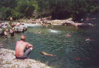
Barton Creek
swimming hole Gus Fruh Pool
Photo courtesy Chandra Moira Beal |
| Floating
Barton Creek in an inner tube, canoe, kayak
or boat is a favorite local pastime. Keep safety in mind and always
wear a lifejacket, even if you are an experienced swimmer. The creek
is shallow and dotted with trees and rocks which can easily upset
your boat. Other hazards to watch out for are fire ants, water and
land snakes, poison ivy and prickly plants. Wear sunscreen and river
shoes or tennis shoes to protect your feet. Never float during rain
or thunderstorms or during periods of flooding as the water can become
muddy and hide hazards. Drink lots of water. Never boat or tube alone.
|
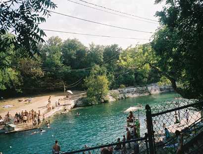
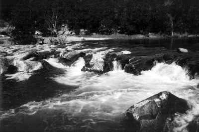
Sculpture Falls
Photo courtesy Chandra Moira Beal |
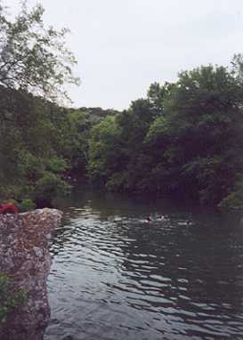
A
number
of swimming holes dot Barton Creek and are accessible from the Greenbelt.
Catfish Pool is just below the junction of Barton Creek and
Hebbingston Hollow. A small footbridge traverses the north side. Sculpture
Falls has rapids and secluded sunbathing, just below Dam #7. Campbell's
Hole has a small pebble beach and is a reliable pool. It's located
about one mile upstream from Barton
Springs. Legend has it that Robert E. Lee made numerous trips
here while stationed at a camp to the west; Sam Bass, Bonnie and Clyde,
and Jesse James also used the small cave above the pool as hideouts.
Gus Fruh Pool is another reliable swimming hole even during
droughts. It's located near 2632 Barton Hills Drive (respect private
property). Triple Falls and Gus Fruh Park are at the
three-mile mark on the trail and have large boulders and deep water.
Twin Falls can be accessed at Loop 360 across from the entrance
to Barton Creek Mall. You will find a rope swing and good swimming
under two small waterfalls. Most access points have rest rooms and
picnic tables. Of interest is Airman's Cave, a 2.1-mile long
cave. It is the longest cave in the country with an average height
of only three feet. Only five percent of the cave is tall enough to
stand up in, and usually one person gets stuck every year and has
to be rescued. For experienced spelunkers only!
The Austin Chronicle published an excellent guide to hiking
in the Barton Creek Greenbelt and floating Barton Creek in their April
17, 1992 issue, reprinted in April 18, 1997... Page
4 - Zilker Park
Barton Springs and Zilker Park
continued ›
Barton Springs: Page 1
- 2 - 3 - 4
Book Hotel Here › Austin
Hotels |
Barton Springs
TE Editor's
Note: This chapter is the text for pages 27 through 37 of Splash
Accross Texas - courtesy of the book's author, Chandra Moira Beal.
Thorough in research, rich in history, description and recreational
information, this engaging chapter should be read in it's entirety.
However, for quick reference for internet users, we take the liberty
of breaking up the chapter by topics ( in sequence ) as follows:
About
Barton Springs
Sunken
Gardens,1947 Bathhouse, The Environmental Debate
Maintenance,
& Endangered Barton Springs salamander
Philosopher's
Rock, pecan tree
The
Pool
The
Polar Bear Club, Barton Creek Greenbelt, New Trail
Barton
Creek
Swimming
Holes in Barton Creek
Zilker
Park
Botanical
Garden, Zilker Zephyr miniature train ride
Zilker
Hillside Theatre, Austin Nature Center, McBeth Recreation Center,
Beverly Sheffield Education Center
Butler
Brick Company
Addendum:
Barton Springs Endangered Salamander
Book Hotel Here › Austin
Hotels
|
|
|