|
|
History
on a Pinhead
The name is believed to have come from the gate on
a fence that crossed the tracks of the Beaumont, Sour Lake and Western
Railroad.
It was 1911 when the plat for the community was drafted, but it was
two years before it was filed. A post office was in operation from
1912 through the mid 1920s.
The town seems to have peaked with a population of 60 in the 1950s.
The town had three businesses. There is no discernable town center
and buildings are dispersed. It retained its listing as a community
as late as 1990. |
EASTGATE, TEXAS
By Carolyn
Heinsohn
Author's
Note:
I have relatives who settled in Eastgate in Liberty County.
[Here is] a history I wrote up for my book.
|
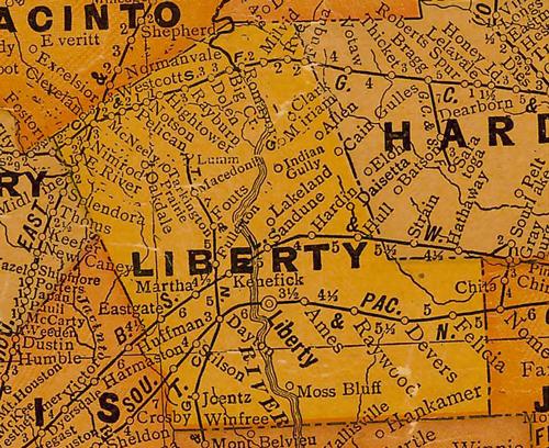
The little village
of Eastgate that never quite materialized according to its original
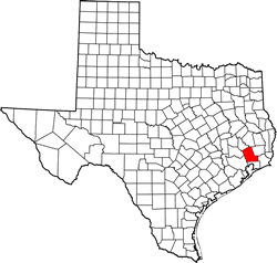
plan is located near the junction of FM Rd. 1960 and 686, thirty-three
miles northeast of Houston
in western Liberty
County. The name of East Gate (later Eastgate) came about
in 1908 when the Beaumont, Sour Lake and Western Railway was built
through the area that was thickly populated with cattle ranchers with
large herds of cattle. For their convenience, so that they would not
have to build loading pens and platforms, the railroad built the necessary
pens with gates at the west and the east fences. It was at the east
gate that the village of Eastgate had its beginnings. At that time,
it was wild cattle prairie country, uncultivated and flat with no
drainage.
The town plat was drawn by J.C. Perry in 1911, but it was not filed
until two years later. However, I.J. Gallia from Engle,
Texas in Fayette
County, who had moved to Houston,
was a land agent who was promoting tracts of land formerly held by
railroad companies which offered much of these holdings as collateral
for their operations. Some of these companies fell into bankruptcy,
and their landholdings were advertised in local and New York newspapers.
Apparently, Gallia and Perry collaborated in acquiring these tracts.
Gallia was then influential in selling this land to Czech families,
which included the Janaceks and Fi�ers from Fayette
County. Some of the land around Ammannsville
was sandy and not very productive, so the Czechs in that area were
looking for better land. They were told that the land in the Eastgate
area was not sandy and would retain water. However, they were not
told that the soil had a high clay content, which would retain too
much water in times of excessive rain.
In 1912, four more families arrived - Joseph and Rudolph Hajovsky
from Fayette County,
Vinc Buchta from Sealy in Austin
County, Karel Parma from Bryan,
Bartos Vyoral, John Kovalcik and M. F. Janacek. The Czech families,
with their usual vigor, went to work to break the land for farming,
which in the beginning was rather poor and produced few crops, but
as the land was worked over and over, better and better crops were
produced. In 1915, additional families arrived; namely, those of Anton
Smykal, Moric Beran, Joseph Vyoral and Joseph Krajca.
In July 1915, Mass was celebrated for the first time with six families
present. This was the beginning of the origin for this being a Czech
parish. At first, a priest only came every three months; however,
later it was once a month. In 1917, the local Czechs began contemplating
the idea of building a Catholic church. With this idea in mind, Emil
Hajovsky and Marcell F. Janacek made rounds among all of the Czech
Catholics to collect monies for a church. With another donation made
by the Catholic Extension Society, a church was built in 1918 on two
acres of land donated by Anna Fi�er Janacek. The furnishings were
purchased with various donations, including $184.00 again donated
by Anna Janacek. The church was named St. Anne in honor of Anna, a
benevolent donor who contributed a substantial amount of money in
addition to the land for the church. Two acres for a cemetery were
donated by I.J. Gallia, the land broker who had sold the initial tracts
of land. |
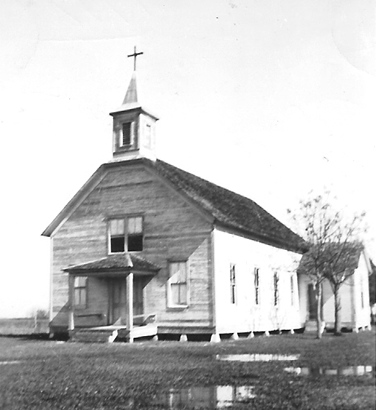 |
St. Anne's Catholic
Church in Eastgate, 1938
Courtesy John Janacek Photo Collection |
In 1948, it
was decided that a larger church was needed, so M.F. and Vlasta Janacek
donated two and one fourth acres of land located approximately two
hundred yards south of the old church in the Eastgate "townsite".
With considerable effort, the parishioners raised the funds necessary
for the church's construction under the supervision of brothers M.F.
and Henry Janacek, grandsons of Peregrin and Filomena Fi�er; they
also designed the building. The brick veneer structure trimmed in
white brick d�cor around the windows and doors had a 44-foot steeple
and a seating capacity of 300. It was built at a cost of $20,000,
because the labor was donated. The old church was used as a parish
hall for a while until it was dismantled and replaced with a new parish
hall.
M.F. Janacek owned the Eastgate Cash Store that was located on his
property. Along with the store, he also had a dance platform, which
was often used for church picnics, and an ice house, which provided
ice for cooling prior to electricity. The store was the center of
the community - a place to shop, visit, and share the local news.
A post office was operated from 1912 to 1925.
A cotton gin was established by the J.E. Navratil family, which they
operated into the 1930s and then sold to Oscar Sobotik. Adolph and
Rosie Filip and family occupied their residence with Mr. Filip serving
as the ginner under the Sobotik ownership. The gin was later acquired
by Anton Bederka, who operated it until the 1950s.
During the World
War II era, rice farmer Ed Stoesser began acquiring land along
the northern side of the railroad from Czech farmers, who had formerly
cultivated the area. The economy changed during and after the war,
plus a trend toward rural depopulation was caused by government controls
on crops, especially cotton, and
cuts in quotas, all of which caused a loss of income and forced moves
in search of jobs in urban areas. Increasing mechanization, which
replaced manual labor, also contributed to large scale operations
that were consuming the small farmers, in spite of the added conveniences
of paved roads, electricity, communications and other technology.
Stoesser drilled his first major irrigation well almost directly across
the road from the east side location of the Joe D. Fisher home. Rice
fields could be seen far into the horizon. The well more than paid
for itself within the first year as demand for rice increased.
During the mid-1950s, Eastgate had a peak estimated population of
60 persons and three businesses. Churches, a cemetery and scattered
buildings were dispersed in the area in 1990, when Eastgate was still
listed as a community, although the original vision for something
bigger was just a "pipe dream".
© Carolyn
Heinsohn
June, 2014 |
 |
| Texas
Escapes, in its purpose to preserve historic, endangered and vanishing
Texas, asks that anyone wishing to share their local history and vintage/historic
photos, please contact
us. |
|
|