|
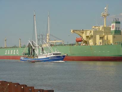
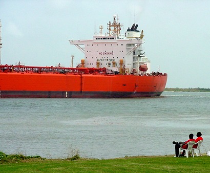
An outbound
shrimpboat passes an incoming tanker on the Sabine River estuary
which connects Sabine Lake with the Gulf of Mexico.
TE Photo March 2007
|
Getting
There
To get to Sabine Pass, you would head south from Beaumont
on Highways 89/96/ 287. After passing numerous prisons and the site
of Spindletop
on your right, you'll pass the Nederland
exits and come to the intersection with highway 87. Take a right and
drive until it intersects with highway 82. To the south you'll see
the easy-to-spot MLK
Bridge. Turn right here on highway 82 and this will take you into
Sabine Pass. Turning left would take you to downtown Port
Arthur. Long before you come to Sabine Pass, you'll start noticing
torn and twisted debris with an occasional stranded boat on the horizon.
As you enter Sabine Pass, you can see that a lot of debris has been
removed - based on the numerous bare foundations and empty posts that
once held signs. |
Bert
Karrer-Lions Park
At the main intersection, a small park is to your left (look for the
old lighthouse lantern and watchroom) and the cemetery is about
a quarter of a mile to the right - on the south side of the road. |
|
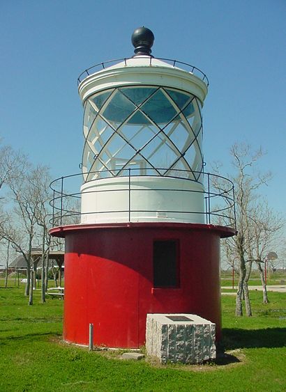
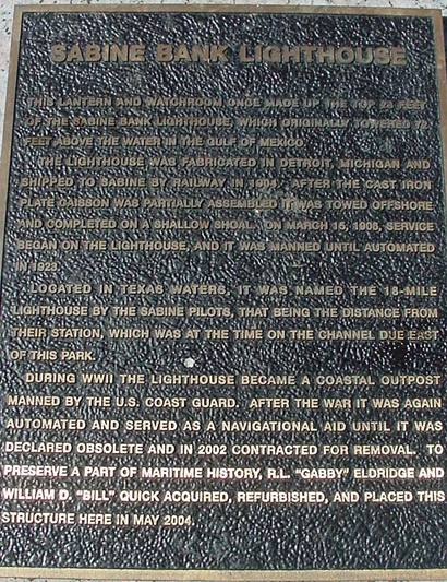
The Sabine Bank
Lighthouse lantern in Bert Karrer-Lions Park. The still-functioning
lens is on display in a Port Arthur Museum.
TE photo, March 2007
|
Sabine Bank Lighthouse
Marker
TE photo, 2007 |
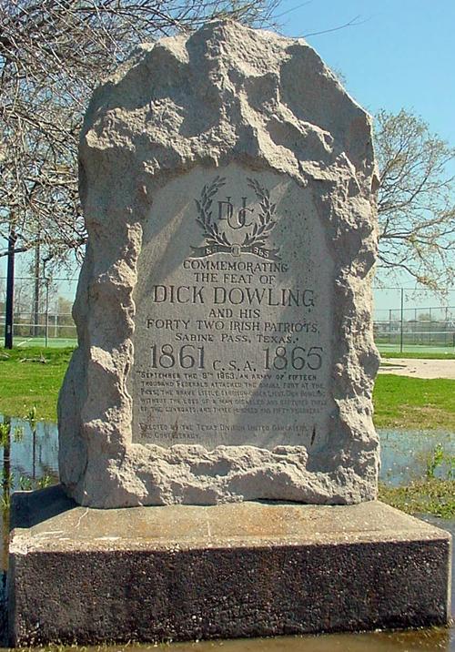
| On
the way to the cemetery (also on the south side of the road) you will
see the granite marker erected by the Texas Division of the United
Daughters of the Confederacy to commemorate
Dick Dowling's lopsided defeat of the invading Union gunships
in 1863. |
The
Sabine Pass Cemetery
The Sabine Pass Cemetery is just to the west of the
town's main intersection while the battleground is several miles south.
The cemetery, which is still in use, has a deep and wide vacant spot
in the middle. Although there are no tombstones, Mr. Block informed
us that an estimated 100-150 people are buried in several mass graves
here - hastily dug during a Yellow Fever epidemic.
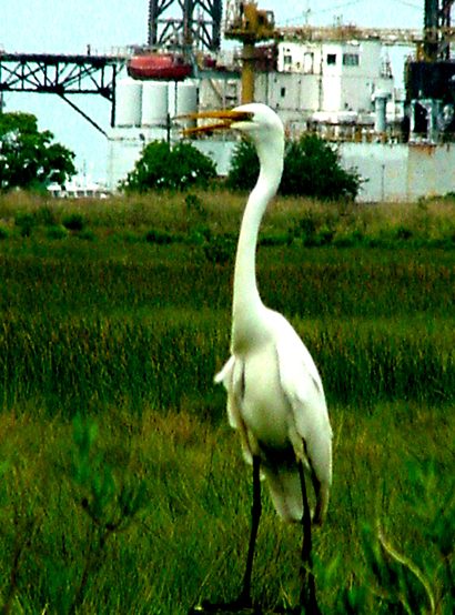
The area abounds in wildlife and during our visit Ken Rudine, who
is an avid birder, identified a large flock of white and black Egyptian
Ibis that were wading in large puddles looking for food. |
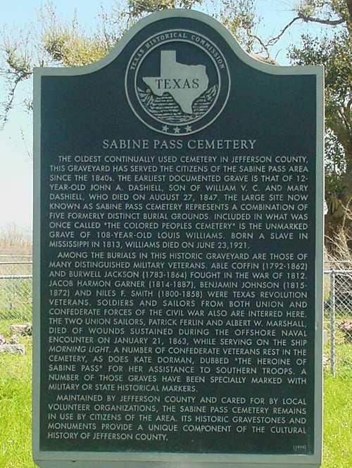 |
According to
the historical marker, the cemetery contains the remains of both Confederate
and (at least two) Union soldiers as well as veterans of the War of
1812, the War for Texas Independence and the reason for our visit,
the final resting place of Kate
Dorman, the "heroine of Sabine Pass."
Among the Yellow Fever victims and fallen soldiers, there also the
remains of a young man who died in 1901 as a result of of shooting
into a pit of unexploded ordnance left in an abandoned gun emplacement.
His remains were covered and a cenotaph placed in Port
Arthur's Evergreen Cemetery.
While the cemetery isn't fenced in black iron or rich with funereal
statuary, it's a memorable cemetery to visit for its typical coastal
flora and fauna - and for its somber timelessness.
Sabine Pass
Cemetery - more images |
Sabine
Pass Battleground State Historic Site
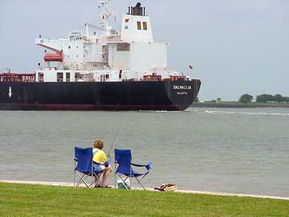
To get to the battleground park, return to the intersection
and go right on 3322. This road follows the Sabine River estuary and
is plied by ships entering Port Arthur,
the gas terminals and refineries or the Neches River which passes
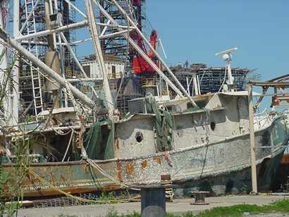
alongside downtown Beaumont. Damage
from Rita is evident in many forms - including the barnacles on this
shrimpboat (above).
The battleground boat ramp and parking lot is open although most of
the visitor's area (including Dick Dowling's statue) is currently
surrounded by ugly flexible orange construction fencing. The status
of the once-numerous historical markers is not known. The thing least
affected by the storm is the grouping of WWII
era ammunition bunkers.
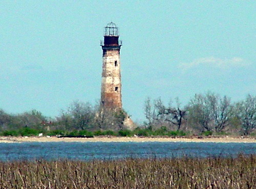
The road south from the Battlefield is a potholed unpaved road that
eventually reaches the site of Sabine
City, a ghost town that once had a railroad connection. The decommissioned
Sabine Pass Lighthouse (on the Louisiana side) is visible access the
marshes and the faded paint and weathered cement give it a watercolor
effect. A painting of the lighthouse in better days is hanging in
the Museum of the Gulf Coast in Port
Arthur.
See Sabine
Pass Battleground State Historic Site › |
 |
Another view
of the Sabine River Estuary at Battlefield Park
TE photo, July 2003 |
Rita was Here.
Barnacles had time to form on this once partially submerged shrimpboat.
(On the way to Sabine
Pass Battlefield)
TE photo, March 2007 |
The old lighthouse
on the Louisiana side of the channel is visible from just south of
the SPBSHS.
TE Photo March 2007 |
If
you're planning a visit to Sabine Pass, you might consider waiting
awhile. Highway 87 between Sabine Pass and High
Island has been shown on TxDoT maps as "temporarily" closed since
1989. Mr. Block corrected our guess that the damaging storm was Carla.
Specifiaclly it was damaged in August of 1989 by a "very small"
storm named Chantille, repaved shortly after and then damaged heavily
by Hurricane Jerry in October of that same year.
Our visit had the best guide imaginable and a bird expert to boot.
Even in the current state, it's a drive worth taking for a picnic
or ship or lighthouse-spotting.
See what you can and try to squeeze in a visit to the first-class
museum in downtown Port Arthur.
Book
Your Hotel Here ›
Houston
Hotels
Beaumont
Hotels
Port
Arthur Hotels
More Hotels |
Editor's Note:
On a beautiful Spring day after a heavy downpour, TE photographic
contributor Ken Rudine
and TE editor decided to visit author, historian and columnist W.T.
"Cannonball" Block at his home in Nederland.
Mr. Block was kind enough to guide us to the Sabine
Pass Cemetery (which we had missed during our Pre-Hurricane Rita
visit in 2003) so that we might get a photo of the marker erected
to Kate Dorman. Mr. Block had been instrumental in having the official
marker installed - as well as manually punching out aluminum plaques
for many of the unmarked graves in the cemetery. The cemetery, which
had been unkept for years, had a new THC marker erected recently and
now receives a yearly cleaning by county workers and volunteers. |
Sabine Pass,
The Town
One of the Eight Corners of Texas
Population: 1,500
in 1984 � now included in the Port
Arthur census. |
History in a Pecan Shell
The town dates from 1836. The town�s future as a major port once seemed
very promising.
The post office was granted in 1846 and the town was incorporated
just before the Civil War. Fort Sabine and Fort Griffin were constructed
nearby to prevent Union incursions into East
Texas.
Yellow fever in 1862 caused an exodus of locals, but prevented the
Union Army from occupying the town. The battle of Sabine Pass in 1863
was one of the most lopsided victories of the entire war. It made
a hero of Houston saloonkeeper Richard
Dowling and his victory left him with a bronze
statue at the battleground and a marble
statue (and a street named after him) in Houston.
Dowling�s niece, who was held in high regard by Texas society �
was buried in the State
Cemetery in Austin, although her father rests in Houston's St.
Vincent's Cemetery.
The 1880 population was 460 people - making Sabine Pass Jefferson
County�s second city.
The Sabine and East Texas Railroad that appeared in 1881 replaced
a prewar line that had been abandoned.
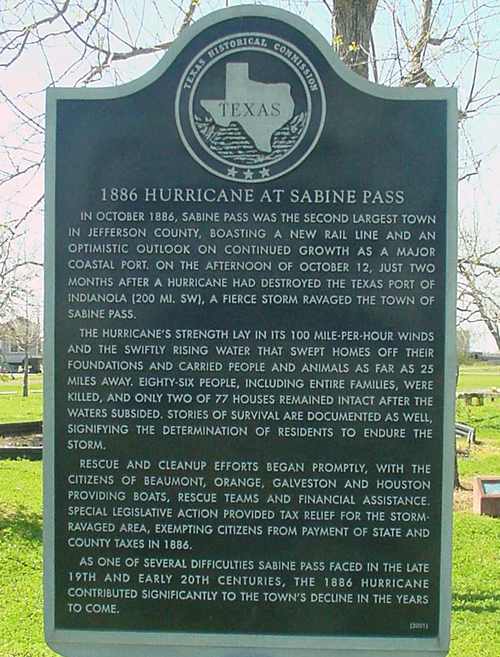
The towns limitless future was dimmed when a hurricane
in 1886 destroyed the town and killed 86 residents. Storms struck
again in 1900 and 1915.
In the late 1800s, The Kountze brothers, who owned vast acreage in
Jefferson County,
refused to negotiate with developer Arthur Stilwell. Stilwell decided
to pour his money and energy into Port
Arthur instead. As Beaumont, Orange
and Port Arthur grew - Sabine
Pass traded its promising potential for guaranteed tranquility.
The 1900 population was a mere 363 people.
Port Arthur eventually annexed
the town in 1978, although the town maintains an entirely separate
identity. |
 |
Historical Marker
- Sabine Pass Lions Park, Sabine Pass
City of Sabine
and Sabine Pass
The first known
settlers in this area were John McGaffey and Thomas Courts, who arrived
in 1832. Sam Houston
assisted Manuel de los Santos Coy in acquiring a land grant here in
1833. Two years later Houston and two partners purchased Coy's property
holdings. On January 19, 1839, Gen. Sam Houston signed the charter
that established the city of Sabine. Houston was active in
promoting the sale of 2,060 town lots. The city soon flourished. Houston
and his partners lost title to the town when the General Land Office
determined that John McGaffey held original claim to the lands.
The city of Sabine developed into a major port. In 1860 the State
Legislature, in approving a new charter for the city, changed the
name to Sabine Pass. It was the scene of a major Civil War
engagement in 1863, with Confederate forces preventing a Union attempt
to capture the port and gain major inroads into Texas.
The Federal Harbor Act of 1882 led to construction of jetties here
and development of inland ports along the Neches and Sabine rivers.
By the early 20th century Sabine Pass began to decline due to hurricane
damage which prevented railway maintenance. |
 |
|
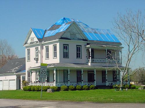
An ante-bellum
house, said to be the Pass' oldest home, undergoes repair. It has
weathered worse storms than Rita.
TE Photo 3-2007
|
|
|
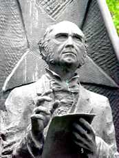
Sam
Houston makes up part of a larger sculpture
in the city park.
TE Photo, 7-2003 |
 |
Port Arthur
Tourists Information
The Port Arthur
Chamber of Commerce
4749 Twin City Hwy, Suite 300
Port Arthur, TX 77642
(409) 963-1107
The Port Arthur Convention & Visitor's Bureau
3401 Cultural Center Drive Port Arthur, TX 77642
1-800-235-7822
Website - http://www.portarthurtexas.com/ |
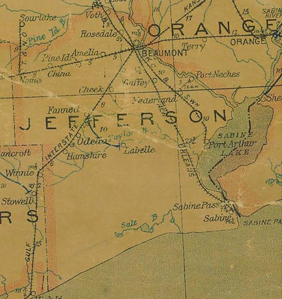
Jefferson
County 1907 postal map showing Sabine Pass
Courtesy Texas General Land Office |
| Texas
Escapes, in its purpose to preserve historic, endangered and vanishing
Texas, asks that anyone wishing to share their local history, stories,
landmarks and recent or vintage photos, please contact
us. |
|
|