|
|
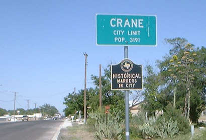
CRANE, TEXAS
Crane
County
Seat, West Texas
31� 23' 35" N, 102� 21' 3" W (31.393056, -102.350833)
Hwys 385 and 329
32 miles South of Odessa
21 miles North of McCamey
Population: 3,723 Est. (2016)
3,353 (2010) 3,191 (2000) 3,533 (1990)
Book Hotel Here › Odessa
Hotels |
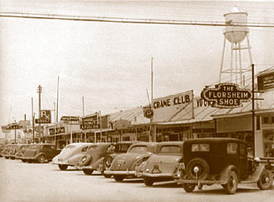
Crane street
scene with water tower, 1940s
Photo courtesy texasoldphotos.com |
Both
county and city were named after Wm. Carey Crane who was a
founder of the old Baylor University in Independence,
Texas.
Crane
County was formed in 1887 from land that had once been
Tom Green County.
The county was finally organized in 1927. In 1890 there were a reported
15 people who had coffee with the census enumerator.
History in
a Pecan Shell
Even as Crane entered the 20th Century, the cattle and sheep outnumbered
the people by a ratio of 420 to 1.
That meant 51 people and 21,400 animals in 1900.
They got a post office in 1908. By 1918 they started building roads
and by 1920 there were only 37 people left in the county.
The oil boom
changed that. The same regional boom that brought in the towns of
Wink, McCamey,
Iraan, and
Notrees added an overnight
population of thousands of land speculators, workers and camp followers.
Mr. Ollin Columbus Kinnison* platted
a townsite and named the streets after his children.
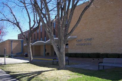
The need for a
courthouse was addressed in 1927 - the year the county was organized.
Other city amenities came as the oil sold. At one point - water was
so scarce that women sent their laundry to El
Paso by train.
The population reached 1,400 in 1940. It should be remembered that
1941 was the year that Texas' rural population was outnumbered by
its urban population. In Crane's case, the urban population always
outnumbered the rural.
Oil continues to be Crane's main revenue source. Farming has never
been big in Crane
County and Cattle is a distant second source of revenue.
|
 |
Crane City Limit
Photo courtesy James Rowland |
"Horsehead
Crossing of the Pecos"
7 miles South of
Crane on US 385 is a marker signifing the "Horsehead Crossing of the
Pecos". Although the crossing could not be pin-pointed due to flooding
and conditions, this is thought to be the vicinity.
The name stems from an abundance of horse and mule skulls found there.
The animals died from drinking too much water too fast. The crossing
wasn't used after the coming of the railroad, but before that it was
the only logical low-water crossing for miles. It was a crossing for
Indians, stagecoaches and cattleherds. |
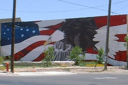
Patriotic mural
in Crane
Photo courtesy James Rowland, 2004 |
|
|
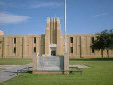
Crane High School
Photo courtesy James Rowland, 2004 |
|
|
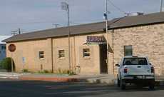
Crane
Police Station
Photo courtesy James Rowland, 2004 |
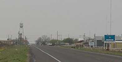
Crane street
scene
Photo Courtesy Charlene Beatty Beauchamp |
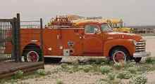
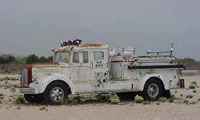
Fire trucks in
Crane
Photo Courtesy Charlene Beatty Beauchamp |
Crane
Tourist Information
Crane Chamber of Commerce: 432-558-2311 |
|
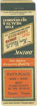
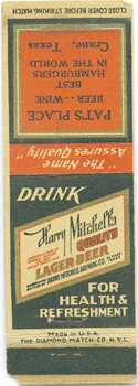
Forwarding
scan of a matchbook cover in my collection of Texas memorabilia.
Does anyone remember Pat's Place, know when this business opened
and closed, or have a photo? - Tom KC, April 14, 2006
|
|
|
Subject:
picture of "picture show"
Dear Editor, I lived in Crane in thirties until 1947, and how fondly
I remember the "Picture Show" on Saturday afternoons for 10 cents!
I am looking for a photo of the "picture show" on the main street
during that time. Could you help me find one? Thanks ever so much,
Carolyn Boren Adams, November 26, 2005
Dear Editor,
In surfing the web, I came across your excellent web site about
the city of Crane in West Texas. I was
fascinated since you have a picture of the red fire truck I took
in 1949, as a Volunteer Fireman, to the gas station to fill up with
gas and � well, it is a long story, too long for this email, but
you can find it already on the internet, on our website: www.booksonhistory.com.
You will find it when you click on the excerpt for my book, �Angel
Kisses and My Beating Heart, My Life and Near-Death Experiences.�
When I wrote that book I realized how important Crane was in my
life. I think I have at least 26 pages devoted to life in Crane,
some with pictures similar to the ones you have.
(A new congregation in 1945 that had been granted the privilege
of using the Crane County courthouse as their temporary quarters.
In my book there are pictures and the story of how we built the
building that is now the Catholic Church in Crane.)
Thanks for your Website. We have taken the liberty of adding a link
to your site from our page of �Places�. Your site is fun and we
thought others ought to have a chance to know about Crane.
P.S I hope this information might put me in contact with others
who remember me and my wife, Karin, who married me during my days
in Crane.- Jack CO. Ramsay, Former pastor of the Presbyterian Church
of Crane, October 25, 2005
I was born
in Crane Texas in 1949 I used to live and play on top of the Old
Court House. I haven't been home in 43 years. Please keep up the
good work. - Jean ( Dozier ) Cundall, July 15, 2002
In the 1950's,
the first Courthouse was an apartment house. I loved growing up
in Crane. If could I would move back. When I was young the town
seemed to be one large family. That's what I want to get back to.
- A child of a Great small town, July 16, 2002
I was born
in Crane, Texas. My grandparents were James Robert (Bud) Boyd and
Mary Elizabeth Boyd. He was Cty. Commissioner and listed several
places in a Crane genealogy site. They were 2 of the original founders
of the First Baptist Church of Crane and are buried in Crane.
Hope to see more photos of Crane. I remember the fire chutes of
the high school and the light in the tower when we won football
games. - Sandy, Crane, 06/Jul/2002
What a surprise
to see downtown Crane on the Internet! Also, to see the Crane water
tower that I used to try to climb as a girl!
My grandfather was JK Price longtime city manager of Crane in the
50s and 60s. Thanks for the memory Ms Beauchamp! - Jonette, Flower
Mound, 22/Jun/2002
Correction
*I ran across the Texasescapes.com
website recently & a reference to my great grandfather, Ollin Columbus
Kinnison. You spelled his name as O. C. Kimmison. We've seen the
same error on the etexas.edu website & requested it be corrected.
Thanks. - William Gaston Kinnison, III Redmond, WA.
|
| Texas
Escapes, in its purpose to preserve historic, endangered and vanishing
Texas, asks that anyone wishing to share their local history and recent
or vintage/historic photos, please contact
us. |
|
|

 Texas
Gulf Coast
Texas
Gulf Coast East
Texas
East
Texas Central
Texas North
Central
Texas North Central
Texas South
Central
Texas South Texas
Panhandle
Texas
Panhandle South
Texas
South
Texas Texas
Hill Country
Texas
Hill Country West
Texas
West
Texas Texas
Ghost Towns
Texas
Ghost Towns Texas
Counties
Texas
Counties