| Ghost
Towns |
Counties |
Description |
| Aberdeen |
Collingsworth
|
Once
a choice for county seat |
| Acuff |
Lubbock
|
Not
on the state map |
| Admiral |
Callahan
|
A
cemetery remains, and historical markers |
| Adobe
Walls |
Hutchinson |
Site
of the Battles of Adobe Walls |
| Acme |
Hardeman |
Population
14 |
| Afton |
Dickens |
Population
50 |
| Afton |
Fisher |
All
that�s left is the Afton cemetery |
| Alcino |
Floyd
|
Near
Floydada |
| Alanreed |
Gray |
On
old Route 66 |
| Allred
|
Yoakum |
Late-blooming
ghost town |
| Alpha
|
Hutchinson |
Remembered
by vintage maps & postmark |
| Ample |
Haskell |
Remembered
by vintage map & postmark |
| Anarene |
Archer |
Not
on the map |
| Antioch |
Stonewall |
Became
Oriana |
| Arvana |
Dawson |
Appeared
before 1909 |
| Atoka |
Coleman |
Ruins
& cemetery with historical marker remains |
| Auto |
Howard |
Remebered
by a postmark |
| Ayr |
Deaf
Smith |
A
brief life-span of five years |
| Back
City |
Gray
|
1927
Back No. 1 Oil and Gas Gusher site |
| Balch |
Hockley/Lubbock |
A
railroad stop |
| Bartonsite |
Hale
|
Waited
for a railroad that never arrived |
| Bautista |
Moore |
Not
on the map |
| Belle
Plain |
Callahan
|
AKA
Phantom U |
| Ben
Ficklin |
Tom
Green |
County
seat rivalry decided by a flood |
| Benoit |
Runnels |
Still
on the county map |
| Bippus |
Deaf
Smith |
Near
New Mexico state line |
| Blue
Gap |
Runnels |
AKA
Norwood |
| Boise |
Oldham |
Just
south of I-40, formerly Route 66 |
| Bomarton |
Baylor |
With
a church |
| Boyd
Chapel |
Jones |
Historical
Marker |
| Boydston
|
Gray
|
Population
0 |
| Bradshaw |
Taylor |
Population
61 |
| Bridgetown |
Wichita |
Wooden
footbridge remembered by historical marker |
| Bronco |
Yoakum |
Ghost
town with a watering hole |
| Broome |
Sterling |
Once
a railroad stop |
| Bullock |
Eastland/Stephens |
Not
on the map |
| Bullock |
Young |
Population
0 |
| Bunker
Hill |
Dallam
|
Not
on the map |
| Burkett |
Coleman |
Population
30 |
| Caddo |
Stephens |
Located
on a former Caddo Indian campsite |
| Callahan
City |
Callahan
|
Almost
the county seat |
| Camp
Colorado |
Coleman |
Moved
from Mills County in 1856 |
| Car |
Mitchell |
Remembered
by a vintage map |
| Cedric |
Crosby
|
Lost
to Rall |
| Chamberlin |
Dallam
|
Population
0 |
| Champion |
Nolan |
Population
8 |
| Chautauqua
1-29-23 |
Callahan |
Population
0 |
| Chicago
|
Dawson |
Only
a historical marker remains |
| Clairemont
|
Kent |
Former
Kent County seat with courthouse & jail |
| Clara |
Wichita
|
A
cemetery full of Iris |
| Coble
Switch |
Hockley |
Skeleton
of a cotton gin remains |
| Codman |
Roberts
|
On
the Panhandle and Santa Fe Railway |
| Cofferville
|
Lamb |
A
deserted cotton gin remains |
| Coldwater |
Sherman/Dallam |
Former
county seat of Sherman County |
| Content |
Runnels |
AKA
Tokeen |
| Conway |
Carson |
On
Route 66 |
| Copenhagen |
Hale |
In
the cemetery |
| Crews |
Runnels |
Population
25 |
| Crystal
Falls |
Stephens |
Population
10? |
| Cummins |
Sterling |
Historical
Marker |
| Curry |
Stephens |
Submerged |
| Cuthbert |
Mitchell
|
Near
the Abrams No. 1 oil well |
| Cuyler |
Carson |
On
the Panhandle and Santa Fe Railway |
| Dad's
Corner |
Archer |
A
boom town ghost town |
| Damsite |
Hardeman |
Not
even on the county map |
| Decker
|
Nolan |
A
cemetery remains |
| Denton |
Callahan |
Population
6 |
| Desdemona |
Eastland |
A
boom town ghost town |
| Doan's
Crossing |
Wilbarger
|
The
Friendliest Red River Dog |
| Dora |
Nolan |
A
cemetery remains |
| Dozier
|
Collingsworth
|
Near
the Salt Fork of the Red River |
| Drasco |
Runnels |
Close
to the Taylor county line |
| Draw |
Lynn |
"The
store" |
| Dressy |
Callahan |
A
cemetery remains |
| Dundee
|
Archer
|
Named
after the city in Scotland |
| Dunlap |
Cottle |
Town
began with the splitting up of OX Ranch |
| Durham
|
Borden |
Only
a cemetery remains |
| Echo
|
Coleman
|
Not
on the state map |
| Eclipse
|
Gaines |
Remembered
by a postmark |
| Edith |
Coke
|
Only
cemetery remains |
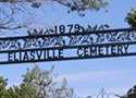
| Eliasville |
Young
|
A
ghost town with a burned flour mill |
| Eldridge |
Gray
|
First
Cemetery in Gray County 1888-89 |
| Electric
City |
Hutchinson |
Furnish
electricity to the oil fields |
| Elmdale |
Taylor |
Within
Abilene city limit |
| Emma |
Crosby |
Second
Crosby County seat |
| Eolian |
Stephens |
Population:
9 |
| Erskine |
Concho |
Remembered
by a postmark |
| Eskota |
Fisher
|
A
ghost town with an annual Homecoming |
| Espuela |
Dickens |
Only
the cemetery remains |
| Estacado |
Lubbock |
First
County Seat of Crosby County |
| Farmer |
Young
|
Cemetery,
school bus & oil rig |
| Farwell |
Hanford
|
First
town in Hanford County |
| Flat
Top |
Coleman |
Named
after a bunkhouse |
| Fort
Chadbourne |
Coke
|
S
of the old Fort Chadbourne |
| Fort
Chadbourne |
Coke
|
The
old fort |
| Fort
Elliott |
Wheeler |
A
centennial marker remains |
| Fort
Griffin |
Shackelford
|
AKA
The Flat, one of Texas� most lawless towns |
| Fort
Phantom Hill |
Jones |
Built
in the 1850s |
| Fort
Picketville |
Stephens
|
First
Stephens County seat |
| Frankel
City |
Andrews |
Once
had over 100 producing wells |
| Frankell
|
Stephens |
Once
populated by oil workers |
| Fry |
Brown |
Population
0 |
| Gasoline |
Briscoe |
The
cotton gin burned |
| Gazelle |
Hall |
Post
office closed in 1902 |
| Geraldine
|
Archer |
Remembered
by a historical marker |
| Gewhitt |
Hutchinson |
Near
County seat Stinnett |
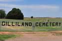
| Gilliland |
Knox |
Much
reclaimed by nature |
| Gilpin
|
Dickens |
Population
3 |
| Glazier |
Hemphill |
A
cattle and grain shipping point |
| Glenrio |
Deaf
Smith |
The
last Texas stop heading West on Route 66 |
| Goodnight
|
Armstrong |
Home
town of "Hud" |
| Gooseneck |
Young
|
A
Cemetery |
| Gomez
|
Terry |
One
name, two ghosts |
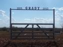
| Grady
|
Fisher |
A
small cemetery remains |
| Grape
Creek |
Borden
|
Absorbed
by Gail |
| Gray
Mule |
Floyd |
On
the Quitaque Canyon Trail |
| Griffith |
Cochran |
Not
on the map |
| Guion |
Taylor |
Not
on the map |
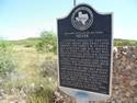
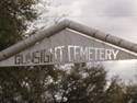
| Gunsight |
Stephens |
Population
6, church & cemetery |
| Hansford
|
Hansford |
First
Hansford County seat |
| Hart
Camp |
Lamb |
Population
8 |
| Hatchel |
Runnels |
Population
16 |
| Hayrick
|
Coke |
First
Coke County seat |
| Hindman |
Dawson |
Remembered
only by a map |
| Hitson |
Fisher |
History
on a historical marker |
| Hud |
Scurry |
On
vintage maps |
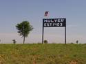
| Hulver |
Hall
|
Only
the cemetery remains |
| Hutson
|
Brown |
Found
on 1920s map |
| Hylton |
Nolan |
Population
6 |
| Hyman |
Mitchell
|
A
church & a cemetery |
| Iatan |
Mitchell
|
A
Cemetery |
| Ibex
9-1-18 |
Shackelford |
Oil
boom town with smokestack ruins |
| Ideal |
Sherman |
Fermerly
in Hutchinson County |
| Isom |
Hutchinson |
Absorbed
by Borger |
| Janes |
Bailey
|
Near
Muleshoe |
| Jean
|
Young
|
Named
after ... |
| Jeffry |
Hutchinson |
Near
Adobe Walls |
| Jericho |
Donley
|
Home
of "Jericho Gap" of Route 66 Fame |
| Jewel |
Eastland
|
Settled
in the 1870s |
| Jimkurn |
Jimkurn |
Oil
boom ghost town |
| Julia |
Borden |
Appears
in the 1907 postal map |
| Justiceburg |
Garza
|
Near
Post and Snyder |
| Kerrick |
Dallam
|
On
the Oklahoma State line |
| Key |
Dawson
|
East
of Lamesa |
| King's
Mill |
Gray
|
Near
Pampa |
| Kirkland |
Childress |
Once
the "Biggest Little City in Texas" |
| Klondike |
Dawson
|
East
of Patricia |
| Knapp |
Scurry |
Population
10, historical marker & church |
| La
Casa |
Stephens |
With
historic church & cemetery |
| Lakeview |
Lynn
|
Population
unknown |
| Laketon |
Gray
|
Near
Pampa |
| Landergin |
Oldham |
Not
on the map |
| Leaday |
Coleman |
Displaced
by Lake Ivie |
| Lehman |
Cochran
|
County
seat rivalry |
| Lesley |
Hall |
Not
on the map |
| Lillie |
Collingsworth
|
Once
part of Rocking Chair Ranch |
| Link |
Mitchell |
Remembered
by a cancelled postmark |
| Lipscomb |
Lipscomb |
Lipscomb
County seat |
| Litwalton |
Garza |
In
1907 postal map |
| Loco |
Childress |
Only
cemeteries remain |
| Lone
Wolf |
Tom
Green |
Absorbed
by San Angelo |
| Lonnie |
Childress |
Remembered
by ghost of a church |
| Lou |
Dawson
|
Not
on the map |
| Loveless |
Concho |
"Southeast
of Eden" |
| Lutie |
Collingsworth
|
Began
as part of Rocking Chair Ranch |
| Luzon |
Kent |
Not
on the map |
| Mabelle |
Baylor
|
Centennial
Baylor County marker is there |
| Machovec |
Moore |
Grain
elevators standing |
| Magenta |
Oldham |
Only
a cemetery remains |
| Mangum |
Eastland |
Once
shipped bottled water |
| Mankins |
Archer |
Once
home to a wild west circus |
| Maple |
Bailey |
With
a Cotton Gin Coop |
| Margaret |
Foard |
First
Hardeman County seat |
| Marie |
Runnels |
Not
on the map |
| Masterson |
Moore |
Not
on the map. Near Lake Meredith |
| Maverick
|
Runnels |
Not
on the map |
| McLean
POW Camp |
Gray
|
A
ghost community |
| Medicine
Mound |
Hardeman |
A
Museum remains |
| Mendota |
Hemphill |
Once
center for grain & cattle |
|
Mesquite
|
Borden
|
NOT
the Mesquite in Dallas County |
| Middle
Water |
Hartley
|
Division
of the XIT Ranch |
| Middlewell |
Moore |
Not
on the map |
| Mingus |
Palo
Pinto |
Born
with the arrival of the railroad |
| Michies |
Dawson |
Remembered
only by a map |
| Montvale
|
Sterling |
A
cemetery and historical marker |
| Mobeetie
|
Wheeler
|
"Hard-luck
Capital of the Panhandle." |
| Moro |
Taylor |
Near
Mount Moro |
| Mount
Blanco |
Crosby |
First
permanent homestead in Panhandle South Plains |
| Mount
Pleasant |
Taylor |
Historical
markers & Castle Peak |
| Mozelle
|
Coleman |
A ghost town with a high school |
| Mulock |
Hansford |
Existed
as a post office |
| Mungerville |
Dawson |
A
schoolhouse remains |
| Narcisso |
Cottle |
Population:
0 |
| New
Moore |
Lynn |
No
longer on the map |
| Newlin |
Hall |
Abandoned
bank and a store |
| Newman |
Fisher |
Church
& cemetery remain |
| Norfleet |
Hale
|
On
north bank of Brazos River |
| Norton |
Runnels |
Population
96 |
| Nubia |
Taylor |
Population:
Unknown |
| Ochiltree |
Ochiltree |
Former
Ochiltree County seat |
| Odell |
Wilbarger
|
Near
the county seat |
| Ogden |
Cottle |
Population
0 |
| Oil
City |
Hutchinson |
Population
0 |
| Old
Pease City |
Foard |
Town
site historical marker remains |
| Olfen |
Runnels |
With
a 1922 Romanesque church |
| Olga |
Nolan |
On
Coke and Nolan county line |
| Opdyke |
Hockley
|
Started
in 1925 |
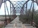
| Oriana |
Stonewall |
Oriana Camelback Truss Bridge |
| Otis
Chalk |
Howard |
Once
a boom town |
| Oxien
|
Runnels |
Not
on the map |
| Pansy |
Crosby |
Not
on the map |
| Parmerton
|
Parmer |
Former
Parmer County seat |
| Parnell
|
Hall |
School
ruins remains |
| Patricia |
Dawson |
Look
for Poco Crudo Longhorn |
| Pep
|
Hockley |
Once
part of XIT Ranch |
| Perico |
Dallam
|
Once
the shipping point for the XIT Ranch |
| Phillips
|
Hutchinson |
Obliterated
by the 1980 explosion |
| Picketville
|
Runnels |
Not
on the map |
| Pickwick |
Palo
Pinto |
Under
Possum Kingdom Lake |
| Plemons |
Hutchinson |
First
Hutchinson County seat |
| Plymouth
|
Collingsworth
|
Once
part of Rocking Chair Ranch |
| Polar
|
Kent |
Not
on the map |
| Pride |
Dawson |
Absorbed
by Welch |
| Proffitt
|
Young
|
Church,
schoolhouse & cemetery |
| Pumphrey
|
Runnels |
Not
on the map |
| Pyron
|
Scurry |
Once
a thriving community |
| Ramsdell |
Wheeler
|
Site
of first area telephone system. N of Route 66 |
| Rayner
|
Stonewall |
The
first Stonewall County Seat |
| Record |
Hansford
|
Not
on the map |
| Rich
Coffey |
Coleman |
On
the property of Richard Coffey |
| Rising
Sun |
Shackelford |
Remembered
by a postmark |
| Rock
Crusher |
Coleman |
A
missed chance of the ultimate team name |
| Rockledge |
Donley
|
Two
murders and a bank robbery |
| Rolla |
Collingsworth
|
Population
unknown |
| Ronda |
Wilbarger
|
Ronda
Cemetery |
| Rowe |
Donley
|
Rowe
Cemetery |
| Roxana |
Carson |
Oil
boom town |
| Runnels
City |
Runnels |
Only
the centennial marker remains |
| Running
Water |
Hale
|
Bypassed
by the railroad |
| Ruth |
Concho |
Not
on the map |
| Sanco |
Coke |
Named
for a Comanche chief |
| Scherz |
Tom
Green |
Near
San Angelo |
| Sedwick |
Shackelford |
Once
an oil boom town |
| Shafter
Lake |
Andrews |
Lost
the �county-seat war� |
| Shep |
Taylor |
Not
on the map |
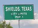
| Shields |
Coleman |
Cemetery
remains |
| Silver |
Coke |
Once
a pioneer ranching center |
| Silver
Valley |
Coleman |
Alongside
the Pecos and Northern |
| Sligo |
Yoakum
|
Not
on the map |
| Soash |
Howard |
Not
on the map |
| South
Bend |
Young
|
Ghost
spa |
| Spade |
Mitchell
|
A
cemetery with historical marker |
| Sparenberg |
Dawson
|
Population
20 |
| Stevens |
Sherman |
Grain
elevator standing |
| Sunshine
Hill |
Wichita
|
Highest
elevation in Wichita County |
| Swastika |
Hale |
Without
a trace (on any map) |
| Swearingen |
Cottle |
A
cemetery shown on detailed county maps |
| Swedonia |
Fisher |
A
Swedish ghost town |
| Swenson |
Stonewall |
With
ruins and a church |
| Talpa
|
Coleman |
Close
to Ballinger |
| Tampico |
Hall |
Ozark
Trail at Tampico |
| Tascosa
|
Oldham |
Home
of Cal Farley�s Boys Ranch today |
| Tee
Pee City |
Motley |
Only
a centennial marker remains |
| Tesco |
Nolan |
There
used to be a town in the location |
| The
Flat |
Shackelford
|
AKA
Fort Griffin, one of Texas� most lawless towns |
| Thrift |
Wichita
|
A
Red River Ghost Town |
| Tokio
|
Terry |
Sort
of between Big Spring and Lubbock |
| Tolbert |
Wilbarger
|
Originally
named Wheatland |
| Tredway
|
Borden |
Appears
in the 1907 postal map |
| Trickham |
Coleman
|
The
Oldest Town in Coleman County |
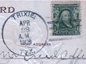
| Trixie |
Gaines |
Encounter
with a Texas "Bad Man" |
| Truitt
|
Runnels |
Not
on the map |
| Truscott |
Knox |
Once
named China Lake |
| Valera |
Coleman |
Once
a ranch |
| Valley
View |
Cottle
|
Not
on the map |
| Valley
View |
Runnels |
Not
on the map |
| Verbena |
Garza |
Not
on the county map |
| Vigo
Park |
Swisher
|
Named
after Vigo & Parker counties in Indiana |
| Virginia
City |
Bailey |
Aspired
to be the county seat |
| Voss
|
Coleman |
Hometown
of Representative Bob Turner |
| Walthall
|
Runnels |
Only
the cemetery remains |
| Washburn
|
Armstrong |
Almost
the county seat |
| Wastella |
Nolan |
Hauled
water, & no cemetery |
| Wayside |
Armstrong |
Founded
as a rural school district |
| Westbrook
|
Mitchell |
Another
bypassed small town |
| Westover |
Baylor |
Historical
markers |
| Whiteflat |
Motley |
Originally
a Matador Ranch line camp |
| Whitfield |
Swisher
|
Once
had two churches & a two-room schoolhouse |
| Whittenburg |
Hutchinson |
Now
part of present-day Phillips, Texas |
| Whon |
Coleman |
Touched
by a ranch hand |
| Williams
Community |
Hardeman |
Formed
around its school |
| Wilmet
|
Runnels |
Not
on the map |
| Winchell |
Brown |
With
a bridge & cemetery |
| Zulu
|
Hansford |
Once
grazing land for buffalo |
| More
to come. Check back soon. |